
Environmental Variability
Glaciochemical and stable isotope analyses provide a powerful tool for understanding the history of environmental change (eg., marine storminess, volcanic activity, anthropogenic pollutants).
Sea Ice
The source regions for precipitation falling in coastal Antarctica (elevations up to 2000 m) are located near the edge of the circum-Antarctic marginal sea ice zone. Additional source areas are open water polynyas and leads within the sea ice. As stated above ∂ 18O and ∂ 18D stable isotopes in snow accumulation provide an indicator of the parent moisture source regions. However, the chemical species, sea salts Na+ and Cl-, together with methanesulfonic acid (MSA) provide a reliable proxy for sea ice extent in ice core time series. Recent study by, for example, Welch et al. (1993) has shown the strong correlation between the time series of MSA in ice core records and the continuous records of sea ice extent (Jacka, 1990).
The circum Antarctic retrieval of ITASE ice cores will enable a proxy history of the variability in sea ice extent and concentration to be developed from the data on accumulation rate, seasonality, sea salt and MSA concentration.
Volcanic Input
Sulphate concentrations in ice cores provide a proxy record of volcanism. Stratospheric SO4 aerosols greatly increase over Antarctica following volcanic eruptions around the globe. These and more local events provide stratigraphic marker horizons, evidence of atmospheric circulation pathways and data for testing the effect of aerosol-forcing on climate.
Anthropogenic Input
The influence of human activity on climate and atmospheric composition over Antarctica has already had profound effects. Unexpectedly, the continent has been subjected to massive ozone depletion as a consequence of its unique setting in relationship to global circulation systems and the introduction of humanly engineered CFC's that have ozone destroying side-effects.
Recent changes in Antarctic snow accumulation and sea ice extent have been potentially linked to greenhouse gas warming (eg., Morgan et al., 1991; Vaughan and Doake, 1996).
Human source nuclear fall-out from bomb tests and the Chernobyl nuclear accident (Dibb et al., 1990) demonstrate the potential for the introduction of anthropogenic source pollutants to the continent.
Biogeochemical Cycling and Trace Gas Concentrations
Changes in C, S and N cycles can be tested through analyses of ice cores. Recent work by Etheridge et al. (1996) at Law Dome has demonstrated the tight link between ice core measurements of CO2 in trapped gases and the modern instrumental record. However, relatively little is known about recent changes in other biogenetically and radiatively important chemical species.
The trace gas composition of the atmosphere over the last 1000 years has varied according to natural and anthropogenic processes. Over the last 200 years the atmospheric composition of CO2, CH4 and N2O has changed under anthropogenic influences (Etheridge et al., 1996). Firn and ice core retrieval covering the last 200-1000 years will provide an opportunity to analyse the paleo trace gas composition in trapped air in the ice and hence deduce paleo atmospheric compositions. Trace gases such as CO2 and CH4 are well mixed in the Antarctic atmosphere and the record needs in principle to be investigated only in a few cores to obtain the long-term record. Recent (last 50-100 years) continental and regional variations in trace gas composition in the Antarctic atmosphere can be analysed by sampling air in the firn above the depth of pore closure in ice. Opportunities may arise on ITASE traverses to allow for firn pumping at some sites.
Regional and Continental Wide Extrapolation
Remote Sensing
Remote sensing is expected to be an integral part of the ITASE, contributing to route and site selection for the ground-based sampling, and extending parameters measured during this sampling. The remote sensing contributions planned for the ITASE effort are: detailed image maps of the ice surface along ground-based sampling routes; mean annual and mean seasonal ice surface temperature values for the entire continent at 1.25 km resolution; and accumulation rate values over the continent at 25 km resolution. Additional remote sensing data and techniques will also be used to make site-specific contributions to the ITASE effort. In turn, the ITASE ground-based sampling experiments contribute to the development of improved analyses of remote sensing algorithms by providing ground truth and validation information on, for example: accumulation rate, grain size and temperature and other parameters which can be used to improve the analysis algorithms.
Several reasonable digital elevation maps (DEM's) exist of the Antarctic continent, at least for regions north of 81.5deg.S. These are derived mostly from ERS-1 and other satellite radar altimeters, with additional survey data near most of the mountain ranges. The spatial resolution (grid cell spacing) of the DEM's is 5 km in the best of the current DEM's. If a need is identified for better elevation mapping along the ground-based sampling routes, it may be possible to use photoclinometry (eg., Bindschadler and Vornberger, 1994) to improve the existing DEM's along the traverse routes.
The Advanced Very-High Resolution Radiometer (AVHRR) is the logical sensor for a significant portion of the mapping required for ITASE. Its resolution (1.1 km pixel size at nadir) is appropriate for the vast interior of the ice sheet. One-kilometre AVHRR data for portions of West and East Antarctica is available from three sources: National Snow and Ice Data Center (NOAA, University of Colorado), Antarctic Meteorological Research Center (AMRC, University of Wisconsin) and Antarctic and Arctic Research Center (Scripps Institution of Oceanography). East Antarctica is covered by the 4 km Global Area Coverage (GAC) data archived by NOAA. Despite coverage limitations Landsat and SPOT imagery can also contribute significantly in areas near mountains and crevasse fields where smaller pixel size would be important. The upcoming mapping of the entire continent at 25 m pixel size by the Radarsat Antarctic Mapping Project (RAMP) would provide the definitive map set for Antarctica if it becomes available prior to ITASE ground sampling projects; this seems feasible, but acquisition of the RAMP image data has not yet begun.
Along with the ice surface feature mapping, AVHRR may also be useful for grain size mapping and determining the extent of blue ice areas (Warren et al., 1993). Reflectivity of snow in the near infrared (0.9-1.6 um) is a strong function of grain size (Wiscombe and Warren, 1980; Grenfell et al., 1994) as well as illumination, and a band ratio of AVHRR channel 1 (~ 0.8 um) and channel 2 (~1.1 um) gives a strong signal related to grain size while reducing the illumination variation effects ( Hall and Martinec, 1985). Grain size is an important component of the accumulation mapping from passive microwave emission, as discussed below.
As part of the NASA Mission to Planet Earth Pathfinder project, investigators at NSIDC are currently using AVHRR data to calculate ice surface temperature data that will yield a 5 km grid cell size for Antarctica on a twice-daily basis for the period 1982-present, with the last four years at 1.25 km resolution over most areas. The algorithm for this work is derived from Key and Haeflinger (1992). Accuracy of the temperature measurement from the satellite data is expected to be +/- 1 K. Data from the Pathfinder-funded research should be available by the end of 1997.
As part of ITASE, statistical analysis of this data set would be undertaken to determine the mean annual temperature, mean seasonally-averaged temperature, and some measure of the inter-annual variability over the entire Antarctic. This data base could then be compared with the existing 10 m temperature data sets as well as the 10m temperatures gathered on ITASE ground-based sampling projects.
Knowledge of the optical properties of Antarctic snow can be applied to determine the vertical distribution of radiative heating in the snow during the Antarctic summer (Brandt and Warren, 1993) and should provide a link between spectral albedo and wavelength-integrated albedo and satellite radiances in visible and near-IR channels (Grenfell et al., 1994).
Passive microwave emissivity has been shown to be a function of grain size, which in turn depends on accumulation rate (eg., Zwally, 1977). Recently, two papers have been published on the subject of extracting snow water equivalent accumulation from these data (Zwally and Giovinetto, 1995; Davis, 1995). With grain size and mean annual temperature available in the near future from AVHRR-derived algorithms, it should be possible to derive accurate estimates of the accumulation rate of 25 km resolution from the SSM/I data record available from 1987-present.
Mean annual and mean seasonally-averaged temperature from passive microwave brightness can be compared with dD and d18O isotopic variations in surface snow to better constrain the relationship of these isotopic climate indicators with average annual temperature (Shuman et al., 1997).
Coupled surface snow and snowpit measurements (eg., accumulation rate, temperature, snow albedo, snow surface brightness, visible and solar-infrared observations, surface roughness, melt layers, snow grain size, hoar development, emissivity) are planned as verification of remotely sensed snow properties. Snowpit observations combined with visible/near infrared spectral albedo and thermal infrared observations will also be useful for testing/validating radiative transfer modeling of the snowpack. Since modeling of this sort provides the direct link between the physical properties and the optical properties of the snow, model results represent a way to extend the usefulness of physical properties observations obtained in regions where and at times when surface-based albedos are not available.
Meteorology
Automatic weather stations (AWS) units have been installed in remote areas in Antarctica by research programmes from the USA, Australia, India, Russia, Japan, China, France, Italy, United Kingdom, Argentina, Ukraine, Spain, Chile, Korea, Uruguay, Germany and Finland (Figure 10). The basic AWS units measure air temperature, wind speed and wind direction at a nominal height of 3 meters above the surface. Air pressure is measured at the height of the electronics enclosure. Some units measure relative humidity at 3 meters above the surface and the air temperature difference between 3 meters and 0.5 meters above the surface at the time of installation. These data are collected by the ARGOS Data Collection System on board the National Oceanic and Atmospheric Administration series of polar-orbiting satellites. These data have been used to develop synoptic reconstructions, applied to the understanding of atmosphere-snow transfer functions and the interpretation of ice cores and have served a wide variety of other specific science goals.
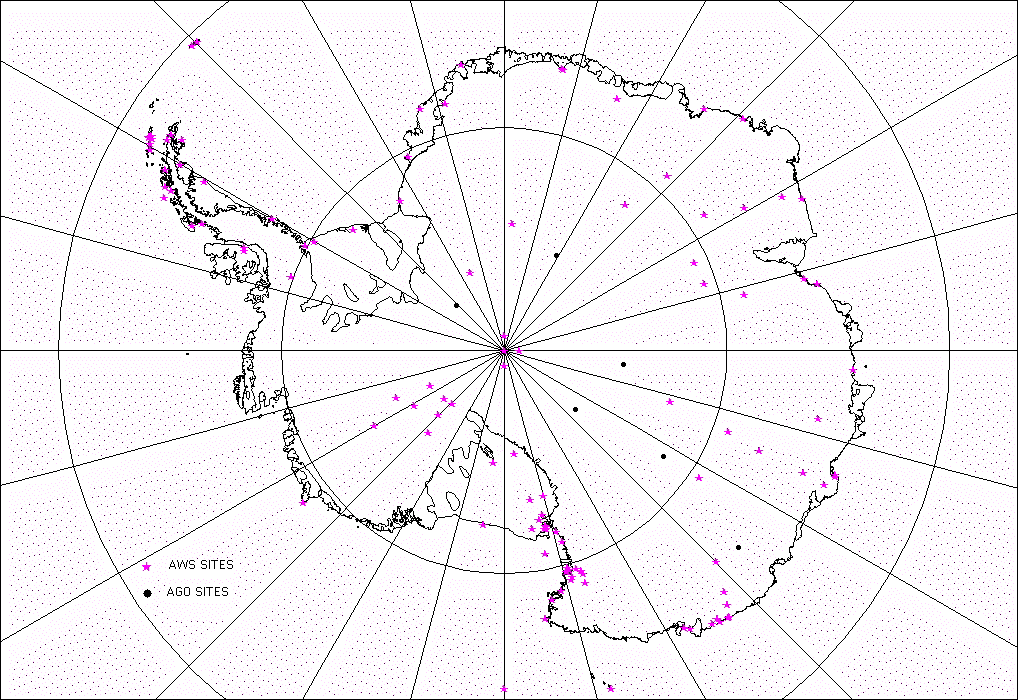
Figure 10 - Map of Antarctica showing locations of widely spaced automatic weather stations (AWS) for 1996, (solid dots) from (Turner et al., 1996, Keller et al., 1997) together with Automatic Geophysical Observatory (AGO) sites where some meteorological data is recorded (solid stars) from the AGO web site http://www.polar.umd.edu/ago.html.
Glaciological accumulation determinations have up to the present been able to depict the time-averaged spatial distribution of Antarctic accumulation, although the temporal averaging is not well constrained. Accumulation time series depicting annual variations are limited in number, and spatial coverage. Atmospheric methods for estimating accumulation (actually precipitation minus evaporation/sublimation, and omitting drift snow transport effects) have recently been developed, particularly for Greenland (eg., Robasky and Bromwich, 1994; Calanca and Ohmura, 1994; Chen et al., 1997), and show good agreement with time-averaged accumulation depictions. Similar efforts are underway for Antarctica and show substantial promise in depicting broadscale accumulation patterns (Yamazaki, 1992; Budd et al., 1995; Bromwich et al., 1995). ITASE offers a unique opportunity to compare atmospheric and glaciological accumulation estimates for the same time periods and for well sampled, very large areas.
Atmospheric numerical analyses are a comprehensive assimilation of all available meteorological observations (from surface weather stations, radiosonde balloons, satellites, etc.) in a consistent fashion. Recent evaluations have shown that the analyses produced by the European Centre for Medium-Range Weather Forecasts (ECMWF) provide a good broadscale depiction of the atmospheric circulation in and around Antarctica (Bromwich et al., 1995; Turner et al., 1996; Cullather et al., 1997). From these analyses the accumulation rate over Antarctica can be determined indirectly. It has been found that on average about 40% of the water vapour falling as snow on Antarctica enters the continent through West Antarctica (Bromwich et al., 1995), in line with earlier estimates (Lettau, 1969). This sector is subject to the largest interannual variability in Antarctica, particularly in conjunction with the El NiÒo-Southern Oscillation (ENSO) phenomenon. As shown by Figure 11 (from Cullather et al., 1996), the derived accumulation rate over part of West Antarctica (180-120 W, 75-90 S) facing the South Pacific Ocean varied in phase with the Southern Oscillation Index (a tropical Pacific pressure index related to ENSO) from 1982-1990 and then became anticorrelated after 1990 in association with the prolonged series of El NiÒo events of the early 1990s (Trenberth and Hoar, 1996). Further, ENSO events observed in the South Pacific Ocean (White and Peterson, 1996) appear to affect both the sea ice cover in this sector (Gloersen, 1995) and pressure and temperature on the continent (Smith and Stearns, 1993).
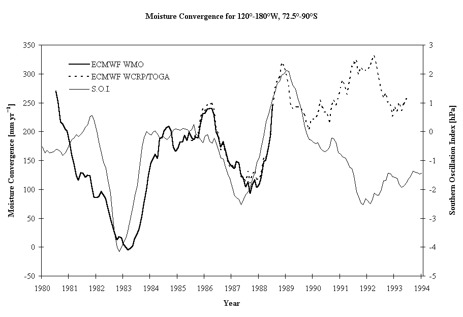
Figure 11 - Precipitation minus evaporation/sublimation (equal to moisture convergence) for the West Antarctic sector between Byrd Station and the central Ross Ice Shelf (75-90 S, 120 W- 180 W) derived from the ECMWF atmospheric moisture budget (bold solid and dashed) in relation to the Southern Oscillation Index (thin solid). Values are annual running means. From Cullather et al. (1996).
Uncertainties exist concerning the quality of the pre-1982 ECMWF analyses. These diagnosed accumulation variations are associated with zonal migrations of the Amundsen Sea low for distances of up to 2000 km (Figure 3). The accumulation variations experienced by other parts of West Antarctica depend on their spatial relationship to the Amundsen Sea low, thus illustrating the complexity in space and time of the ENSO signal in West Antarctic precipitation. Much more diagnosis is needed to understand the dynamics and teleconnections associated with the poleward propagation of the ENSO signal from the tropical to the high latitude parts of the Pacific Ocean (Chen et al., 1996), as well as its impact on the climate of Antarctica. Particularly important is the study of interannual variations of cyclone behaviour in relation to the large-scale atmospheric circulation.
As already noted almost half of the moisture precipitating on Antarctica moves poleward across the coast of West Antarctica between the Ross Ice Shelf and the Antarctic Peninsula. This poleward moist and warm air advection has a profound impact on the surface temperature regime over West Antarctica, as well as the boundary layer dynamics near Siple Coast (Bromwich and Liu, 1996). The potential temperature accounts for the effect of elevation on air temperature readings.