to Quaternary Changes in Relative Sea Level
Shoreline response to sea-level rise
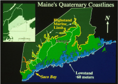
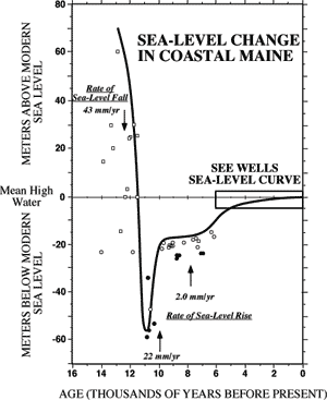
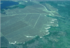
As the glaciers retreated from Maine, their weight depressed the level of the land and caused flooding as far inland as Millinocket (Figure 1a). Deltas made of sand from melting glaciers, such as Columbia Falls (Figure 1b), are now blueberry barrens high about sea level. After the ice melted, the land rebounded and local sea level fell to a depth of 60m below present sea level (Figure 2).
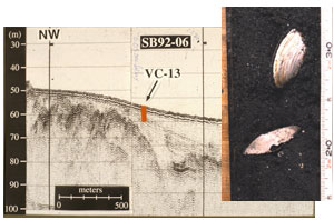
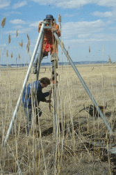
Using remote sensing devices like seismic reflection profilers, we can image through the sea floor to find evidence of lower-than-present sea-level positions (Figure 3). Cores collected in deltas from that time, but now submerged, allow us to date fossils to establish a sea-level history for coastal Maine that is unlike most places (Figure 3).
Sea level slowed down its rate of rise during the past 5,000 years to less than 1 mm/yr, and allowed beaches and salt marshes to develop. Salt marshes (Figure 4) grow upward at the same rate as sea level rises and have proven useful to measure sea-level rise for the past thousands years. Cores through the marsh allow us to plot the rise of sea level for the past few thousand years (Figure 5).
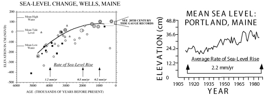
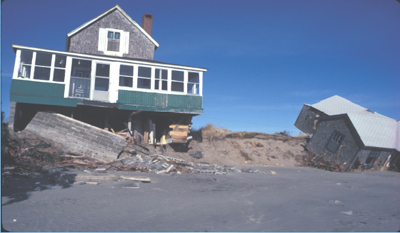
Modern sea-level rise is measured at tide gauges, which indicate a rate of rise between 2 and 3 mm/yr, faster than any time in the past few thousand years (Figure 6). The shoreline is responding by retreating. Bluffs of 13,000 year old marine mud erode rapidly, placing houses at risk. Beaches also migrate landward in response to sea-level rise, leaving homeowners at risk (Figure 6).
Selected References
Barnhardt, W.A., Belknap, D.F., and Kelly, J.T., 1997, Sequence Stratigraphy of Submerged River-Mouth Deposits in the Northwestern Gulf of Maine: Responses to Relative Sea-Level Changes. Geological Society of America Bulletin, v. 109, p. 612-630.
Barnhardt, W.A., Gehrels, W.R., Belknap,D.F., and Kelley, J.T., 1995, Late Quaternary Relative Sea-Level Change in the Western Gulf of Maine: Evidence for a Migrating Glacial Forebulge. Geology 23:317-320.
Belknap, D.F., Andersen, B.G., Andersen, R.S., Andersen, W.A., Borns, H.W., Jr., Jacobsen, G.W., Kelley, J.T., Shipp, R.C., Smith, D.C., Struckenrath, R., Jr., Thompson, W.W. and Tyler, D.A., 1987, Late Quaternary Sea-Level Changes in Maine. In Nummedal, D., Pilkey, D.H., Jr., and Howard, J.D., eds., Sea Level Rise and Coastal Evolution: SEPM Pub. 41, p. 71-85.
Gehrels, W.R., Belknap, D.F., and Kelley, J.T., 1996, Integrated High-Precision Analyses of Holocene Relative Sea Level Changes: Lessons from the Coast of Maine. Geological Society of America Bulletin, z. 108, p. 1073-1088.
Kelley, J.T., Dickson, S.M., and Belknap, D.F., 1998, Maine's History of Sea-Level Changes, Maine Geological Survey, http://www.state.me.us/doc/nrimc/pubedinf/factsht/marine/sealevel.htm
Kelley, J.T., Dickson, S.M., Belknap, D.F., and Stuckenrath, R., 1992, Sea-Level Change and the Introduction of Late Quaternary Sediment to the Southern Maine Inner Continental Shelf. Wehmiller, J. and Fletcher, C., (eds.), Quaternary Coasts of the United States, Soc. Econ. Paleo. and Mineralogists, Special Paper. 48, p.23-34.