Patterns of Radical & Continuous Change Since the End of the Last Glacial Period
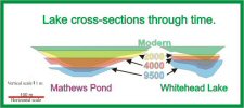
Paleohydrology studies of Mathews Pond and Whitehead Lake in Northern Maine revealed dramatic changes in lake levels since the end of the last ice age. We examined six sediment cores from across a water-depth gradient for each lake. Sediment structure, organic and carbonate content, plant remains, and mineral grain sizes are all affected by changes in lake level. Although these parameters may be affected by other factors as well, taken together, they reveal significant changes in water depth of the two lakes throughout the past 12,000 radiocarbon years.
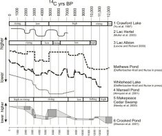
The paleo-environmental data suggest that the late-glacial climate was dry and lake levels were low. Lake levels rose gradually during the early post-glacial period, after 10,000 years ago. Lake levels at both sites declined abruptly about 4800 years ago and remained low until about 3,000 years ago.
By 2000 years ago, northern Maine was gradually becoming wetter. Modern lake levels, which are at the highest level of the past 12,000 years, were probably achieved only within the past 300 years.
Low water levels indicate dry conditions in Northeastern North America throughout the late-glacial period, prior to 10,000 radiocarbon years ago. Conditions across the region were generally wetter from about 7000 to 5000 radiocarbon years ago. A decline of water levels 4800 years ago, recorded at several sites, coincides with a sharp decline in hemlock pollen observed throughout the region. Several sites demonstrate a rapid rise in water level 3000 years ago, with levels continuing to rise until today. Modern water levels are higher than at any point during the past 12,000 years.
Synchrony of lake-level changes between Mathews Pond, Whitehead Lake, and the other northeastern sites, and the time-transgressive nature of mid-Holocene lake-level changes from west to east, provides evidence that periodic, short-term changes in moisture balance are driven by external forces such as changes in atmospheric circulation patterns, solar output, or insolation related to orbital cycles.
Higher resolution analyses should reveal even greater synchrony between lake levels and other climate change indicators.
Selected References:
Dieffenbacher-Krall, A. and Nurse, A. 2005. Late-glacial and Holocene record of lake levels of Mathews Pond and Whitehead Lake, Northern Maine, USA. Jour. Paleolim. 34:283-310.
Muller, S.D., Richard, P.J.H., Guiot, J., de Beaulieu, J.-L., Fortin, D. 2003. Postglacial climate in the St. Lawrence lowlands, southern Quebec: pollen and lake-level evidence. Palaeogeogr. Palaeoclim. Palaeoecol. 193: 51-72.
Almquist, H., Dieffenbacher-Krall, A.C., Flanagan-Brown, R., Sanger, D. 2001. The Holocene record of lake levels of Mansell Pond, central Maine, USA. Holocene 11: 189-201.