

28 Aug 04 – On to Camp 3 – The upper Gurreholm Dal laterals
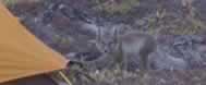
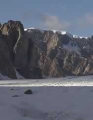
The general objective was to move camp to the upper part of the Gurreholm Dal, near the prominent lateral moraines and the Little Ice Age deposits. When the helicopter picked us up at Camp 2 the temperature was 9° C but when it left us at Camp 3 it was 2°C. Why are we moving toward the snow? Brenda looked the situation over carefully and decided that she had better get back to teach class, so Meredith and Tom had to carry on. Camp 3 (71° 31.9 N, 24°52.9 W, 640 m a.s.l) was located on a terraced boulder field above the highest well-developed lateral moraine on the northeast side of Gurreholm Dal. We hiked up valley to the end of the laterals to measure an estimated ELA of 752 m a.s.l. On the way back, we collected 4 rock samples along the moraine crests. One of these was on a “big boulder”. Sampling boulders is much more fun when there are only two people to hammer. We walked 9.0 km and 800 m relief (mostly tallied in two good sized gullies cutting the moraines). While cooking dinner back at camp, we had a visit by an honored guest. A young fox walked right into camp and decided to investigate our tents, but was scared off when the plastic under one of the tents bit him back.
29 Aug 04 – Little Ice Age
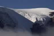
The weather improved some, but clouds hung around the high peaks all day. Tom?s brilliant idea that he came up with in a nice warm sleeping bag was to attempt to get to the Little Ice Age lateral moraine/trimline to measure the representative ELA. The plan seemed “simple” – walk over the Little Ice Age drift and investigate the nature of the drift, then continue either around the side of or on the largest tributary glacier in this system to where the lateral moraine/trimline of the Little Ice Age starts. On arriving at the glacier margin we saw that the fresh snow extended down to the current glacier margin. We recognized this as an important clue that the ablation season for this year is over. We continued along the margin of the glacier until it was a low enough slope for us to get onto the glacier surface. After being stymied by a persistent supra-glacial meltwater stream and observing some refrozen ice on the glacier surface, we made strategic retreat at 900 m elevation – still about 3 km away from where the Little Ice Age lateral moraine/trimline starts. One important observation was a small piece of a terrace that appears to be continuous with the well-developed laterals below Camp 3. The ELA measured yesterday needed to be re-measured to include this terrace. It was also observed that the Little Ice Age drift is at least two different ages so we will have to be careful in picking which one to use as a base for ELA differences to older drifts. The day was almost finished when one final stream which had boulders covered with algae provided an interesting crossing. We walked 17.3 km and 1140 m of relief, again through the two gullies.
30 Aug 04 – Finish up and pull out
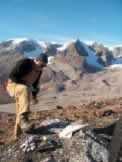
Scheduled the final helicopter pick up for late in the day – just in time so that the Constable Pynt airport staff did not need to work overtime. The weather started out hazy with a solid frost overnight. Later in the day it cleared with a north wind, but clouds built later. On the moraines below camp we sampled three more boulders, totaling at least 5 on the upper lateral moraine. After the helicopter pick up we flew up valley and made first approximate elevation measures of the Little Ice Age ELA, the ELA of the well-developed upper lateral moraines, and the elevations of some high (last glacial maximum?) trimlines. From this exercise it would appear that the ELA depression represented by the lateral moraines below Camp 3 is 270 m. The ELA depression represented by the moraines near Camp 2 is about 700 m. The last day was a record easy day with only 2.8 km of walking and 280 m of relief.