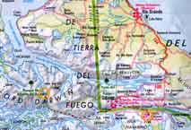
Date: Friday, March 4th 2005
Time: 10:00 pm
Location: S 54.77378 W 69.59059
Temperature: 6°C 43°F
Wind speed: 15 mph
Wind chill:
Altitude: 12 m
Weather: Rain, Rain, Rain
Yesterday we moved all our gear from Ocean Tramp to the base of the Ellis glacier; we were very lucky to have a cloudless, sunny sky for the whole day. We moved to the glacier by loading Charlie’s zodiac with bags, motoring to the beach nearest the glacier, unloading our bags onto the beach, and finally carrying our bags to a good camping spot on the moraine close to the snout of the glacier. This process required three fully loaded zodiac trips to get all our gear to the beach and the hike to our camping spot was difficult because we were moving through long grass that camouflaged rocks and boulders of all shapes and sizes. I think that by the time we were done lugging gear, we all had bruised and bloodied shins! After a brief recovery period, Paul, Andrei, Erich, Scott, and I carried the first load of gear up the glacier and made a cache at 300 m elevation. Mike stayed at base camp to finish setting up the tents and a cooking rock. By the time we got back down to base camp the light was fading, it was a relief to see all the tents up and ready and a pot of water boiling on the stove.
Our base camp is situated about half a kilometer away from a second huge glacier snout that completely dwarfs the Ellis. This other huge glacier is very active and it calves huge ice blocks into the fjord every 10 -15 minutes. When this occurs we are treated to a loud thunder-like cracking sound, something like a large canon! This sound is followed by roaring splashes as the enormous ice chunks hit the water and splinter into millions of pieces. As we drifted off to sleep that first night, the sounds of calving seemed oddly calming.
The Ellis glacier itself is stagnant, this means that its flow rate has slowed considerably and most of its mass is lost through melting. The lower portion of the glacier is composed of freshly broken, angular pieces of granite, some similarly shaped igneous rocks, and solid ice. The rocks range in size from finely ground flour to boulders bigger than a house. These sharp rock fragments litter the surface of the glacier, which is far from smooth. Differential melting causes the surface to become scarred and scoured, covered by ridges and hillocks, add to this crevasses and moulins and you have a recipe for some rather difficult terrain. Moulins are holes melted into the glacier surface that extend downwards and link up with the network of meltwater channels within the glacier that form its primary drainage. Moulins range greatly in size from a few centimeters to something you could drive a train into! Standing on the surface and looking around reminds me of the surface some strange, far-off extra-terrestrial planet or moon. Hard plastic mountaineering boots and crampons are required for travel because these are the best things for keeping a grip on the hard, wet, jagged surface.
Today we carried another load of heavy gear up to the 300m cache site. About 10 minutes into our journey the rain began to fall, and it didn’t stop. By the time we reached the 300m site we were thoroughly soaked. We had originally planned to carry the gear up to 600 m but the weather was getting so bad that we dropped the gear at 300 m and returned back to base camp. To rekindle our damp spirits Andrei cooked up a delicious rice curry for dinner. Unfortunately, the lid of the hot red pepper fell off as he was adding it, so it ended up being extra, super, duper, hot and spicy!!! Delicious!
Previous journal entry, Next entry, return to Patagonia home

 This project is supported by a grant from NOAA, Office of Global Programs


