
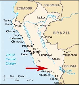
Nevado Coropuna, Peru
This Project is supported by a generous grant from the
Dan and Betty Churchill Exploration Fund
May 16, 2006 to July 15, 2006

This project seeks to better understand links between climate change, the glacial history of the tropical Andes, and the initial human settlement of South America. At the end of the last ice age some 13,000 years ago, early foragers called Paleoindians were first entering South America, one of the last continents on earth to be permanently inhabited by people. This was an exceptionally dynamic time characterized by major environmental transformations: climate patterns were shifting, glaciers were in retreat, and the distribution of plant and animal communities was changing rapidly. How did these early settlers successfully adapt to such changes and rapidly colonize a continent of productive coasts, the rugged Andes Mountains, and the vast Amazon?
Our 2005 Churchill-funded expedition to the Nevado Firura, a 5,499 m high, glaciated volcano, discovered numerous archaeological sites on and among glacial landforms. These sites are possibly the world’s highest elevation Paleoindian settlements. We mapped and sampled glacial deposits of the Nevado Firura in order to reconstruct glacier extent at the time of this early occupation. Our findings validated the Paleoindian coast-highland link and demonstrated that glacier margins can be highly productive environments with abundant water, flora, and fauna – and that periglacial environments may have been vital for the success of Paleoindian populations, just as they are important to Andean peasant communities today. It therefore follows that late-Quaternary ice-marginal zones form a logical starting point for our investigation into early human land-use behavior in the central Andes.
 Understanding the relationship between the contemporary early highland and coastal sites, as well as addressing the question of initial migration, will require additional archaeological work between the highland and coastal locales to “connect the dots.”
Glaciers are sensitive climate indicators, waxing and waning in response to temperature and precipitation fluxes. A record of glacier fluctuation can therefore be used to determine both the timing and magnitude of climate-change events. To reconstruct former glacier extent on Nevado Coropuna we will map the distribution, elevation, and morphology of moraines, drift sheets, erratics and erosional features onto 1:20,000 scale aerial photos. Hand-dug pits will allow sedimentologic and stratigraphic characterization of each unit. We will correlate moraines by position, soil development and physical weathering characteristics of internal and surficial clasts. In addition, we will use a Dutch corer to extract sediment cores from local bogs in order to obtain minimum ages for glaciation. The glacial geologic mapping will be used in close conjunction with the surface-exposure program to ensure careful sampling of moraines and erratics.
Our 2006 research offers an exciting opportunity to explore the relationships between climate and environmental change and the initial Paleoindian settlement of South America at the end of the last ice age. Moreover, our interdisciplinary approach will enable us to pool logistical resources and labor to continue cooperative fieldwork in this remote area of the central Andes.
For further information, see the project page.