
One of the most conspicuous impacts of climate change involves changes in worldwide sea level resulting from melting ice sheets. Joe Kelley's research in Maine has focused on measuring the rate of sea level change over the past 14,000 years, and the accompanying changes in Maine's shoreline. Immediately following glaciation, Maine's coastlines stood well inland due to land submergence. This was rapidly followed by land uplift, and the lowest position of sea level off the Maine coast at about -60 m shortly after the last ice sheet retreated. Using geophysical tools, Kelley along with Dan Belknap and their students, have mapped shorelines and river deltas now drowned under the sea. Lake deposits that were submerged by sea level rise and covered with mud produce methane that currently erupts from the seafloor and scours crater-like depressions hundreds of meters across and tens of meters deep in many of Maine's estuaries. The contemporary rise in sea level is most marked by beach erosion and coastal landslides. Kelley and Belknap, along with the Maine Geological Survey, established a volunteer beach erosion monitoring program for southern Maine beaches. Kelley heads up a landslide hazard mapping effort, with support from the Maine Geological Survey that informs homeowners of the growing hazard of rising sea level. Based on this research, Maine's laws governing beach development and construction set backs from eroding bluffs are considered to be among the most progressive in the country.
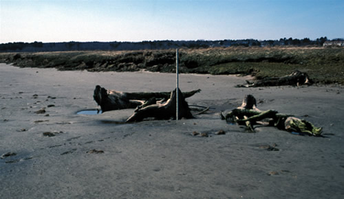
Stumps of 4000-year old trees emerge from beneath an eroding salt marsh in Well, Maine. The forest was drowned 4000 years ago and covered with salt marsh peat, but the system continue to move landward as the ocean continues to rise.
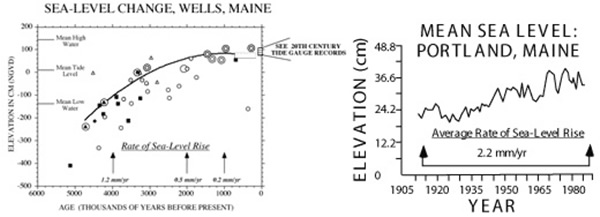
Left figure - Sea level slowed down its rate of rise during the past 5,000 years to less than 1 mm/yr, and allowed beaches and salt marshes to develop. Salt marshes (right figure) grow upward at the same rate as sea level rises and have proven useful to measure sea-level rise for the past thousands years. Cores through the marsh allow us to plot the rise of sea level for the past few thousand years.