
Principal Investigators: Joseph Kelley, Daniel Belknap
Sea and land-level changes have independently influenced the position of the shoreline in Ireland and the rest of the formerly glaciated world since the end of the Ice Age. Global sea level has risen 120 m since 18,000 years ago as a consequence of glacial melting, although the rate of rise/melting has varied over time. Land levels in areas that experienced glaciation have also changed profoundly as a result of crustal depression that accompanied loading of the ice on the earth's surface, and the land's subsequent rebound during ice melting. The fascinating interplay between these linked, but independent, processes has changed the shape of continents and existence of islands, and, thus, controlled the movement of prehistoric peoples. Both processes continue today with serious ramifications for people. In areas where land uplift exceeds the rate of sea-level rise (Norway, Sweden, Finland, much of Canada), shoaling harbors frustrate societies. Where relative sea-level rise dominates coastal behavior (most of the remainder of the world), beaches erode, and coastal cliffs collapse into the sea. Although the changes in global sea level are relatively well understood, land-level adjustments are inherently local and require spatially distributed observations. A powerful approach to understanding land-level changes involves numerical modeling of the physical properties of the earth's interior. As yet, few formerly glaciated areas have enough information on relative sea and land-level changes to calibrate models, so the models cannot hindcast or forecast local relative sea-level changes accurately. What are needed are more observational data on past sea-level positions from formerly glaciated regions.
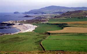
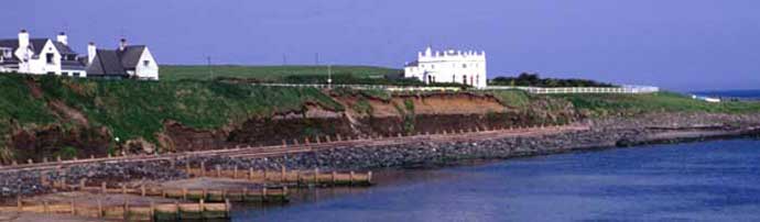
In Northern Ireland, the situation is more complex and less studied. Sea level drowned much of the Causeway Coast as glaciers receded. The land then rebounded, but it is not known exactly how much or when. Sea level has oscillated near the present coast for several thousand years, although the relative roles of sea and land-level changes are not quantified.
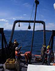
I propose to continue working on sea-level change with Dr. Andrew Cooper and others in the Coastal Studies Group at the University of Ulster at Coleraine. There are two areas where we would focus our efforts. The first would be off the Causeway Coast where we have already collaborated to discover drowned shorelines and possibly drowned peat deposits. I propose to bring over my underwater electric vibracorer to gather the samples. This equipment was a recent acquisition and is especially designed for this sort of work. Dating these features would answer questions concerning the prehistoric insularity of Ireland, and establish a database for modeling sea-level change in northwest Europe.
I believe success here in unraveling the regional history of sea and land-level changes would interest the public as well as other scientists in northwest Europe, the US and Canada; hopefully leading to a joint research effort. Such an effort is already partly underway through UNESCO (International Geological Correlation Programme: Land-Ocean Interactions: Driving Mechanisms And Beyond), and Maine will host an international group of coastal scientists in two years.
Finally, students would be trained to use the GPR and corer and to process the geophysical data. It would also be available to others who might have interests in geological and archeological sites buried beneath dunes or peat bogs, which are transparent to radar imagery.
Check out our Expedition page to see how things are going