
Recent geoarchaeological investigations in the Andes of southern Peru are providing valuable information about the early human settlement of South America, the possible relationship between the highlands and the coast, and adaptation to the ice age environments of this area. Obsidian (volcanic glass) artifacts found at the 13,000 year-old coastal site Quebrada Jaguay by a UMaine team in the 1990s
(Sandweiss et al. 1998) were sourced (Burger et al. 1998) to a geological deposit 165 km away, near the town of Alca in the remote highland Cotahuasi valley (Figure 1). During preliminary work in 2004, we successfully located the major outcrop of the previously identified Alca obsidian source. This new discovery, at 5,000 m (16,500 ft) elevation and with over 20 associated quarry, workshop, and habitation sites (Figure 2), makes Alca the largest known obsidian source in Peru. Many of these sites are situated atop lateral moraines in the Quebrada Pulhuay (Figures 3 and 4); other sites located on the plateau above the Pulhuay cirque apparently pre-date deposition of a diamicton containing striated boulders (Figure 2). The association of these sites with glacial landforms suggests that the sites may be quite ancient, possibly contemporary with Quebrada Jaguay - these sites may be the direct connection between early coastal and highland settlements that we have been seeking.
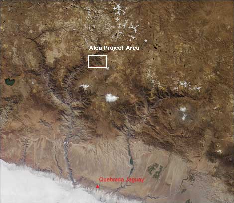
Figure 1:. NASA ASTER L1B image, false color composite. Distance between
Quebrada Jaguay site and the Alca Project area is approximately 165 km (103 miles).
Image courtesy NASA Earth Observatory
Difficulty in interpreting the age of glacial moraines and sediment north of the Nevado Firura (and thus the age of associated archaeological sites) stems from a relatively poor understanding of tropical Southern Hemisphere glacial history, especially during the last glacial termination. Critical issues regarding the timing and spatial extent of ice during the Deglacial Cold Reversal and Younger Dryas climatic episodes remain unresolved, primarily because the little research that has been conducted in the tropical Andes suggests that glaciers in the southern hemisphere behaved differently than those in the Northern Hemisphere after the Last Glacial Maximum (LGM) (Mark et al. 2002; Rodbell and Seltzer 2000).
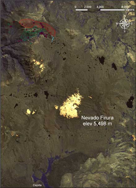
Figure 2. NASA ASTER L1B image of
project area. Green stippled area
indicates obsidian deposit, red stippled
area and dots are archaeological sites, blue dots are striated boulders.
The nature of the last glacial termination in the Northern Hemisphere has been well constrained through a wide variety of proxy. Warming following the LGM was not unbroken but was punctuated by a climatic reversal at ~14.7 ka BP and by the Younger Dryas Stade at ~11 ka BP. The Younger Dryas in particular has received much attention because of the extremely rapid climate changes involved and because of its apparent severity in the North Atlantic region, where temperatures may have returned briefly to full glacial values. Compelling evidence for the Younger Dryas has subsequently been documented from sites throughout the Northern Hemisphere, from regions as diverse as the Arabian Sea and Greenland, but is still lacking from the Southern Hemisphere where the existence of a Younger Dryas stade is strongly disputed.
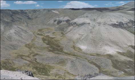
Figure 3. Panoramic photo of Quebrada Pulhuay cirque,
facing southeast. Archaeological sites are located on lateral
moraines within the cirque valley.
To date, glacial geologic research in Peru has concentrated on the moist Cordillera Blanca and Eastern Cordillera, where glacier mass balance is dominated by summer air temperatures. By contrast, the proposed research will examine the record from a remote site in the previously unstudied arid Western Cordillera, where precipitation has a stronger influence on glaciation. Primary objectives include: (1) reconstructing the limits of the Nevado Firura ice cap, from LGM to present; (2) the dating of glacial episodes using a combination of radiometric and surface exposure-age methods; and (3) Geographic Information System (GIS)-based modelling of the local Andean paleoenvironment from LGM to present.
Problems in understanding the initial human settlement of South America are linked to gaps in our knowledge of the glacial geologic history of the Andes during the last deglaciation. Thorough geologic mapping and chronological constraint of the glacial record should enable us to address deficiencies in both areas regarding the timing and extent of regional LGM snowline depression, and thus recent evolution of atmospheric circulation over tropical South America, as well as the climatic nature of the last termination. In addition, the fieldwork will provide valuable insight into the existence of a Younger Dryas readvance in southwestern Peru.
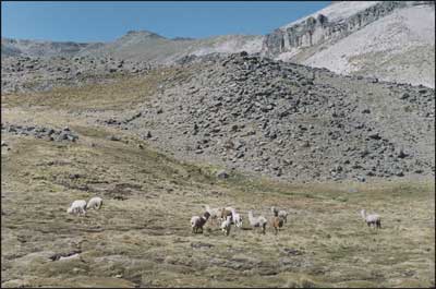
Figure 4: Closeup photo of Quebrada
Pulhuay lateral moraine, facing southeast.
Our proposed field work at the Nevado Firura is also the critical first step in the accurate reconstruction of the local high altitude paleoenvironment. Once we determine the timing and spatial extent of glacial advances and retreats, it will be possible to model other elements of the Terminal Pleistocene and Holocene Andean highland environments, including the distribution and availability of freshwater, biotic communities, and human settlements. Such modelling will be essential for future archaeological research aimed at prehistoric human-ice interactions in the high Andes and other regions. The interdisciplinary expertise and resources of the Climate Change Institute will permit us to form the right team for this work, which will contribute to understanding the ways in which climate change affected tropical southern hemisphere glaciation, high elevation Andean environments, and the initial human settlement of the New World.
References Cited
Burger, R.L., Asaro, F., Trawick, P. and Stoss, F. 1998 Alca Obsidian Source: The Origin of Raw Material for Cusco Type Obsidian Artifacts. Andean Past 5: 185-202.
Mark, B.G., Seltzer, G.O., Rodbell, D.T., and Goodman, A.Y. 2002 Rates of Deglaciation during the Last Glaciation and Holocene in the Cordillera Vilcanota Quelccaya Ice Cap Region, Southeastern Peru. Quaternary Research 57: 287-298.
Rodbell, D.T. and Seltzer, G.O. 2000 Rapid Ice Margin Fluctuations during the Younger Dryas in the Tropical Andes. Quaternary Research 54: 328-338.
Sandweiss, D.H., McInnis, H., Burger, R.L., Cano, A., Ojeda, B., Paredes, R., Sandweiss, M., Glascock, M.D. 1998 Quebrada Jaguay: Early South American Maritime Adaptations. Science 281: 1830-1832
Proposed Field Work
The team will consist of CCI M.S. students Gordon Bromley and Kurt Rademaker, UMaine Anthropology undergraduate Louis Fortin, and Peruvian archaeologist Adan Umire. The American team members will fly from Bangor, Maine to Lima, Peru on June 15. On June 16 we will take an overnight bus to Arequipa, located at 2,325 m (7,630 ft) elevation. There we spend several days acclimatizing to higher elevation, acquire project supplies, and meet with our Peruvian colleague. On June 20, project outfitter Saul Ceron of Inca Tours Peru will transport the team in a Land Cruiser 4x4 to Capilla, a small remote village located in the Andean highlands at 4,400 m (14,435 ft). On June 21 we will load project equipment onto burros, hike approximately 16 km north, and establish base camp between two large lakes on the northwest side of the Nevado Firura at 4,850 m (15,910 ft). For ten days the team will survey and map glacial landforms to the north, west, and southwest of the Nevado Firura at elevations from 4,500 m (14,765 ft) in the Quebrada Pulhuay cirque to 5,200 m (17,060 ft), the modern snowline. We will hand-core moraines and collect samples for radiometric dating, collect rock samples for surface-exposure age dating, and assess the potential of numerous kettle lakes for future extraction of sediment samples for pollen and chironomid analyses. July 2 we will pack supplies and samples on burros to Capilla and spend two days investigating glacial landforms south of the Nevado Firura. July 5 we will return via 4x4 to Arequipa and organize our samples and equipment for transport to Lima. We will take the overnight bus to Lima July 7, arriving July 8, and fly back to Bangor, Maine on July 9. The team will submit a report to CCI upon field work completion.