in the North Pacific
Benjamin Gross, MS Candidate,
Climate Change Institute, University of Maine
Research Problem and Objectives
Unraveling the complex interplay of forcings responsible for changing local, regional, and global climate remains a fundamental challenge in the earth sciences. Using a variety of geologic proxies, significant advances have been made in understanding Earth's climate history and predictive models are now commonly used to forecast 21st century climate (IPCC Fourth Assessment, 2007). The primary method of validating such models is to compare them against instrumental and paleoclimate data. However, instrumental data has only been reliably collected for about a century, so the paleoclimatic record is essential to rigorously testing models because it captures a more complete range of climate variability.
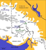
 Geographical setting, weather, and existing research infrastructure make the St. Elias Range an ideal location for studying Holocene climate dynamics through ice cores. Stretching over 100 miles inland from the Gulf of Alaska, The St. Elias Range plays a fundamental role in controlling North American atmospheric circulation and represents the largest area of glaciation outside the polar regions (Figure 1). In addition to being adjacent to the Cordilleran pinning-point of the Rosby Wave system and the Aleutian Low, extreme topography, large annual precipitation, and proximity to the Gulf of Alaska result in a strong coupling between St. Elias Range glaciers and the ocean-atmosphere system. Since 1980, an international group of scientists from the Geological Survey of Canada (GSC), National Institute for Polar Research in Tokyo, University of New Hampshire, and University of Maine have dug dozens of snow pits ranging from 3010 m to over 5500 m and recovered ice cores from Eclipse Icefield (3015 m), King Col (4200 m), and PR Col (5340 m). Low temperatures and high annual precipitation preserve isotopic and chemical signals and the presence of several automated weather sensors (AWS) allows correlation of ice core data with nearby instrumental measurements. Chemical analysis of snow pits and ice cores from these sites have revealed significant altitudinal variations in stable water isotopes (δ18O and δD), pollutant concentrations (Pb, SO42-, and NO3-), and other chemical concentrations (dust, sea-salt, and arsenic; Holdsworth et al., 1991; Yalcin and Wake, 2001; Zdanowicz et al., 2006; Osterberg et al., 2007). These altitudinal variations show water and Pb isotopes to be potential tracers of atmospheric processes resulting in the stratification of moisture and aerosols from proximal and distal provenance. Understanding these processes is vital to constraining the transport of pollutants and moisture in this climatically important region.
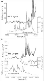
 The Pb flux record from Eclipse Icefield may be correlated with Pb data from Summit, Greenland which displays increasing Pb flux from ca. 1850 to the early 1970's and a decreasing Pb flux since ca. 1976 (Fig. 2; McConnell at al., 2002; 2006). However, the PR Col record displays virtually constant Pb flux from 1850 to the early 1980's, and dramatically elevated Pb flux levels since (Osterberg et al., 2007). The record from Eclipse Icefield may correlate with trends in North American and European industrial emissions, as has been suggested based on SO42- and NO3 profiles (Yalcin and Wake, 2001), while the record from PR Col appears to correlate with industrial emissions from Asia (Osterberg et al., 2007). These relationships have lead to the hypothesis that Asian pollution and North American pollution are vertically stratified within the atmosphere and thus deposited at distinct elevations. However, this hypothesis is based solely on curve comparison and further investigation using a more rigorous geochemical approach is necessary.
The majority of atmospheric Pb comes from anthropogenic sources, such as the burning of coal and leaded-gasoline. When a fossil fuel is burned, the Pb emitted into the atmosphere contains Pb isotope ratios (206Pb/207Pb and 206Pb/208Pb) that are unique to the fuel’s region of origin (Mukai et al., 1993; Rosman et al., 1993; Vallelonga et al., 2002). For example, Pb aerosols from the United States have stable Pb ratios that are distinct from European Pb aerosols (Rosman et al., 1993), and Pb aerosols from Western China are isotopically distinct from Pb aerosols from Eastern China (Mukai et al., 2001). Using the ratio of stable Pb isotopes to trace pollution source could provide important constraints on the amount of vertical stratification in the atmosphere of the North Pacific. I therefore propose to recover shallow ice cores from King Col and Eclipse Icefield, as well as snow pit samples and a fresh snow event (if possible) along King Trench (from Quintino-Sella (2800 m) to King Col) and Eclipse Icefield to be analyzed for Pb isotopes (204, 206, 207, 208Pb). These samples would cover an elevational range from 2800 m to 4200 m and the two cores would update cores previously recovered in 2005 (Osterberg, personal communication). In addition, colleagues from the University of Ottawa and the Geological Survey of Canada will collect snowpit samples at Divide Site.
The ratios of oxygen and hydrogen isotopes in water have long been used as a tracer of the hydrologic cycle (e.g., Schmidt et al., 2007). Mean annual δ18O ratios from snow pits in the Wrangell and St. Elias mountain ranges show a pattern that deviates from monotonic fractionation; that is, from ~3000 to 5300 m isotopic values and are nearly constant or enriched with altitude (Holdsworth and Krouse, 2002). This isotopic excursion has been interpreted to represent the boundaries of the mixed layer within the atmosphere and has put into question the use of oxygen isotope ratios as a proxy for temperature (Holdsworth and Krouse, 2002) in the St. Elias region. Holdsworth and Krouse (2002) and Fisher et al. (2004) have proposed models to explain the anomalous distribution of oxygen isotopes in the St. Elias Range. While both models implicate moisture source as the driving force behind the isotopic anomaly, Holdsworth and Krouse (2002) rely on synoptic-scale polar cyclones and the transport distance of the moisture, whereas Fisher et al. (2004) invoke zonal versus meridional flow. Modeled oxygen isotope anomalies clearly reflect climate changes, yet isotope-based climate reconstructions require critical constraints on the relationship between isotope ratios and specific climate variables (Schmidt et al., 2007). Further understanding of the altitudinal distribution of oxygen isotopes would place important spatial constraints on the relationship between atmospheric processes and isotope ratios, helping to more accurately predict climate with models and reconstruct paleoclimate from ice cores. Accordingly, all ice core, snow pit, and fresh snow samples collected for Pb isotopes will also be analyzed for stable water isotopes.
Past sampling of stable water isotopes traditionally samples the entire range of an annual layer to obtain a mean-annual isotopic value. By sampling an altitudinal transect of fresh snow within 24 hours of deposition, the chemical stratigraphy of a single storm may be identified (e.g., Mayewski et al., 1983). The St. Elias Range is an ideal region to use this sampling method because the sampled snow chemistry could be directly compared to nearby AWS data. Because ice cores are a compilation of heterogeneous (through time and space), independent storms and not annually averaged precipitation, sampling fresh snowfall to ascertain and calibrate the characteristics of individual storms could be invaluable to ice core research. Therefore, should there be an appropriate snow fall, I propose to collect fresh snow samples along a path from Quintino-Sella to PR Col for analysis of stable Pb and water isotopes.
Impacts
I have been invited to accompany Dr. Gerald Holdsworth on his expedition to Mt. Logan in May 2007 to assist him in locating and downloading meteorological data from several AWS’s. Accompanying Dr. Holdsworth is an incredible opportunity for me as his nearly 30 years of climate research experience in the St. Elias Range would be invaluable to the realization of my field objectives and my understanding regional climate.
The benefits of this project include: 1) a unique student field experience in a remote location, 2) laboratory experience, 3) using an innovative array of tracers to investigate atmospheric processes, 4) participating in new stable Pb isotope studies in the St. Elias Range, and 5) specifically testing models proposed by Holdsworth et al. (1991), Holdsworth and Krouse (2002), and Fisher et al. (2004). Recovering ice cores from Eclipse Icefield and King Col gives the added benefit of extending the ice core records at these sites to 2007. This multi-isotope would provide important constraints on atmospheric process using an array of paleoclimate proxies, fresh snow sampling, and instrumental data over a range of elevations in a climatically important region.
Refrences
