
This project is funded by the Comer Science and Education Foundation
Meredith Kelly (Lamont-Doherty Earth Observatory)
Brenda Hall (University of Maine)
August 14, 2004 to August 31, 2004


18 Aug 04 – The southwest laterals of Gurreholm Dal
The morning weather was overcast with low clouds and light winds. We planned to sample boulders on the lateral moraine set on the southwest side of Gurreholm Dal. The downslope portions of these moraines are very dissected and difficult to trace, but well-formed at elevations of 350 m a.s.l. We walked to the upvalley limit of the outer moraine at about 410 m a.s.l., where the moraine becomes a small fan deposit. This elevation may approximate a former ELA position. The three main moraines range over some 60 m in elevation. We retrieved four rock samples on the upper moraine, one on the intermediate moraine and one on the lower moraine. These samples will form a sequence for this side of the valley. Six samples turns out to be a record number of samples in one day for Meredith and we are now claming it as a record for Scoresby Sund. An early dinner at 22:00 – we are starting to get the schedule moved back toward normal. We walked 10.7 km and 680 m of relief. It was a full day of hammering on rocks and the arm muscles are developing nicely, but the need for chisel sharpening is getting dire.
19 Aug 04 – More shells – Konglomeratelv
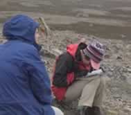
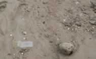
We descended from camp along the east side of Konglomeratelv to collect shells to define the uplift curve. Weather in the morning was partly overcast, but turned sunny in the afternoon. At 105 m a.s.l. we started to find shells and continued to do so down until 36 m a.s.l. We found multiple shell samples from stream exposures but only rarely did we observe shells in their stratigraphic context. We spent considerable time discussing this problem. The species of shell varied with elevation – Mya truncata at higher elevations and more varied at lower elevations. A total of 14 samples put the shell tally in the lead of the rocks. Supper was at 20:30, with time even for hot chocolate. We walked 14.3 km with 780 m of relief.
20 Aug 04 – A big boulder – Gurreholm Slugt
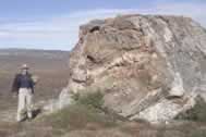
We returned to the area identified as a moraine bank and to the Gurreholm Slugt to measure relic shorelines and sample boulders on the moraine bank. Brenda found the best example of a relic shoreline at about 128 m a.s.l., which may or may not correspond to a sea level of 134 m suggested by Sugden and John in 1965. The general surface texture was observed to change at about 128 m a.s.l., with a smooth surface below and a glacial signature above. On the moraine bank we employed our extensive rock climbing skills toscale the “big boulder” and retrieve a rock sample. Since bigger is better, this was a no-brainer sample that Meredith had been dreaming of for a couple of days. The top was weathered a bit but with a moderate amount of work we got the prized sample. The rock and shell samples from the moraine bank should allow us to date the same feature with two different techniques, providing a cross-check of the methods. We retrieved a total of three rock samples for the day. Since we got home “early” Tom decided to core the small lake above camp. He only got about 15 cm of section with the improvised corer, and it most likely is too young to help this project. We walked 7.7 including the boulder). The evening clouds had the look of snow.