
This project is funded by the Comer Science and Education Foundation
Meredith Kelly (Lamont-Doherty Earth Observatory)
Brenda Hall (University of Maine)
August 14, 2004 to August 31, 2004


21 Aug 04 – On to Camp 2 – The outer laterals of northeast Gurreholm Dal
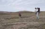
We scheduled a camp move for 10:00, but the morning fog forced us to wait until around noon. Camp 2 (71°25.2N, 24°38.7W and 182 m) was located on the shoulder between Gurreholm Dal and Muslingeelv with a good view to bedrock cliffs of Karstryggen. The helicopter measured a temperature of 9°C and the afternoon was warm. We examined the moraines above camp and discussed tentative correlations and the nature of deglaciation. We also examined boulders on a kame terrace below the lowest prominent moraine and discussed a strategy to date the outer moraines in northeast Gurreholm Dal. We walked down into the valley and discovered that bedrock and unconsolidated deposits are difficult to understand. Only 5 km of walking, an easy day. A file to sharpen the tools arrived- what a good idea.
22 Aug 04 – Shells along the “Staircase” – Muslingeelv
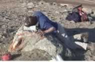
The long awaited trip to the famous “Staircase” is today! Last night a light frost left traces around camp and scattered clouds had the look of snow squalls. But a persistent north wind kept the flies away. We worked down to Muslingeelv (which Brenda thinks means shells) stopping first at the highest deltas. We did not have much luck finding shells in the coarse sediments directly associated with the deltas, but we did find them in adjacent fine grained sediments. More thought is required to connect the shell dates with a specific former sea-level elevation. This point was discussed at some length in the field. Another topic for discussion is where the shells are coming from. We typically found them where active slumping is bringing them to the surface. In the end, 16 sites yielded shells. We walked 16.4 km and 830 m relief.
23 Aug 05 – Wildlife day – the “animal” moraines
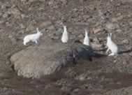
Return to, examine, and hammer rocks on the moraines above Camp 2 was the day's plan. Another frost overnight but high clouds in the morning gave way to completely clear skies by evening. During the course of hammering rocks, the wildlife count for the day was a record: 6 geese, an arctic fox, 4 musk ox, 5 arctic hares and two snowy owls. Given that the various types of animals appeared to prefer certain moraines, we informally named the moraines the Owl, Fox, Rabbit, and Musk Ox moraines (from innermost to outermost). We examined moraines and drift outside of the Musk Ox moraine that should be older than the “animal” moraines. These drifts contained limestone clasts indicating that a glacier lobe from Schuchert Dal intersected the glacier in the Gurreholm Dal. Two samples were retrieved from large boulders on a limestone bedrock surface east of Muslingeelv. These samples should help us identify the last time the two lobes merged. Two boulders on the Musk Ox moraine were sampled as well. We walked 12.2 km and 660 m of relief. We decided that very few boulders in the field area are ideal as samples for surface exposure dating and that compromises are necessary.