
This project is funded by the Comer Science and Education Foundation
Meredith Kelly (Lamont-Doherty Earth Observatory)
Brenda Hall (University of Maine)
August 14, 2004 to August 31, 2004


24 Aug 04 – Shell clean up – Gurreholm Slugt
We made another trip to the “Staircase” (the western side this time) to cover the area. We did not have much luck with the shells along the way but worked down to the active outwash stream below the deltas. There frozen delta sediments are exposed and undercut where the stream is eroding the lower levels of the delta systems. We worked up along Gurreholm Dal and noted the various types of drift which appeared to be mostly at depth. We had extensive discussions about the evidence for former sea levels. A flat-topped deposit of sorted sediment was observed well up valley from where the most likely grounding line is defined. If this deposit is a delta it confirms the idea of former sea levels at about 130 m a.s.l. elevation. No shells were found near the deposit. We continued on to the Owl moraine (the innermost of the animal moraines) and located a granitic boulder associated with striated sandstone bedrock. This “very hard rock” was a two day project but we got a good start on it in the evening. We walked 15.7 km and 615 of relief.
25 Aug 04 – Boulders on the “animal” moraines
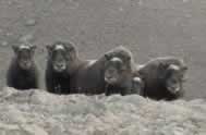
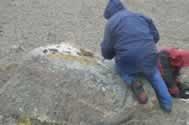
Since we had a start on one sample we decided to hammer boulders along the Owl and Fox moraines. The forecast called for increasingly wet weather during the day, but it turned out to stay pleasant all day until the wind picked up in the evening. This was a day to pound rocks so we did. The rocks lost this round as we ended up with 6 samples. The other data we gathered was that the Fox moraine suggests a former ELA level of about 400 m. Since the Fox and Owl moraines are the lowest moraines on the northeast side of Gurreholm Dal, this ELA estimate should bracket a maximum ELA drop. On the return trip to camp, we walked along the Rabbit moraine searching for potential samples and surprised a small herd of musk ox. Actually, in this situation it was difficult to tell who was more surprised. On our return to camp, we discovered that a musk ox had walked through our bear wire, breaking it on one side on its way in and on the other side on its way out. We walked 8.9 km and 750 m of relief. Of course it is hard to cover much ground when one pounds on 6 rocks in one day.
26 Aug 04 - The rain starts – some rocks
Weather finally had some influence on the work today. Heavy rain and high winds had begun on the prior evening, and we decided to collapse the cook tent to avoid losing it. That plan worked, but it was a challenge to get the tent back up in the morning. The horizontal mixed precipitation continued throughout the day, and we decided to continue sampling on the Rabbit and Musk Ox moraines. We got two rock samples on the Rabbit moraine but found the boulders on this moraine to be much more eroded than those on the Fox and Owl moraines. Spreading the samples out over the various moraines should allow us to document retreat and to check that the exposure ages fall in a consistent stratigraphic order. It took some 8.7 km of slogging around in the rain and 1050 m of relief to get as wet as we did. When the clouds began to clear in the evening, fresh snow could be seen at higher elevations. Brenda and Meredith had a hunch that the “space heater” noted on Tom?s list of supplies for future work was prompted by the recent weather.
27 Aug 04 – Rocks at Gurreholm Slugt, shells at Muslingeelv, and striated limestone bedrock
The weather started out windy and rainy so we warmed up by sampling two boulders near Gurreholm Slugt. These boulders are on a deposit that is an apparent continuation of the moraine bank on the southeast side of Gurreholm Slugt. The samples can be combined with samples from across the river and should give a exposure age on the moraine bank. After a warm-up lunch back at camp, we descended into the Muslingeelv valley. Previously we had spotted what we thought might be small deltas in the upper parts of the Muslingeelv, so they were worth a look. The features in question did have some shells but they did not appear to be deltas because diamictons were exposed at the surface. Four shell samples from these deposits will help define the sea level curve. The limestone forms the cliffs above the Muslingeelv. The bedrock surface above these cliffs was intriguing because of its glaciated appearance and the presence of numerous perched boulders. We had to climb up and look around – if just out of pure curiosity. The surface showed beautiful striae and roche moutonnee forms, carved by a glacier out of the Schuchert Dal. We examined these features and discussed how this area might be suitable to conduct additional sampling to get at the questions of erosion on boulder surfaces and exhumation of boulders from within drift. If we can obtain a field-based estimate for these it will improve the surface exposure age calculations. Because limestone was a theme for the day, on the return to camp we traced drift containing limestone. This “limestone” drift gives us the maximum extent for the Schuchert Dal glacier, an important consideration when we start reconstructing the glacier geometry. We walked 17.1 km and 1760 m of relief. Clear weather had settled in by the evening.