
Overview
History of Programme
In 1990 a meeting held in Grenoble, France brought many of the investigators involved in national ice coring efforts together to report on planned activities and discuss areas of potential international cooperation. One of the major products of the Grenoble meeting was the interest generated in a plan to study the surface and near-surface record of several ice core parameters (eg., accumulation rate, stable isotopes, and snow chemistry) over the major topographic and climatic regions of Antarctica (Figure 1). This plan was soon formulated into a program, called the International Trans-Antarctic Scientific Expedition (ITASE) which based on the scientific representation at that meeting included: Australia, Canada, China, France, Italy, Germany, Japan, Russia, Sweden, Switzerland, United Kingdom and United States. Scientists from several other countries have since demonstrated an interest in the program. It was agreed that a knowledge of the distribution of Antarctica's major environmental parameters (eg., climate, atmospheric chemistry) as measured through ice cores would result in major contributions to the understanding of: global change; Antarctica's sensitive environment; and the interpretative capabilities required to compare existing and proposed ice coring programs.
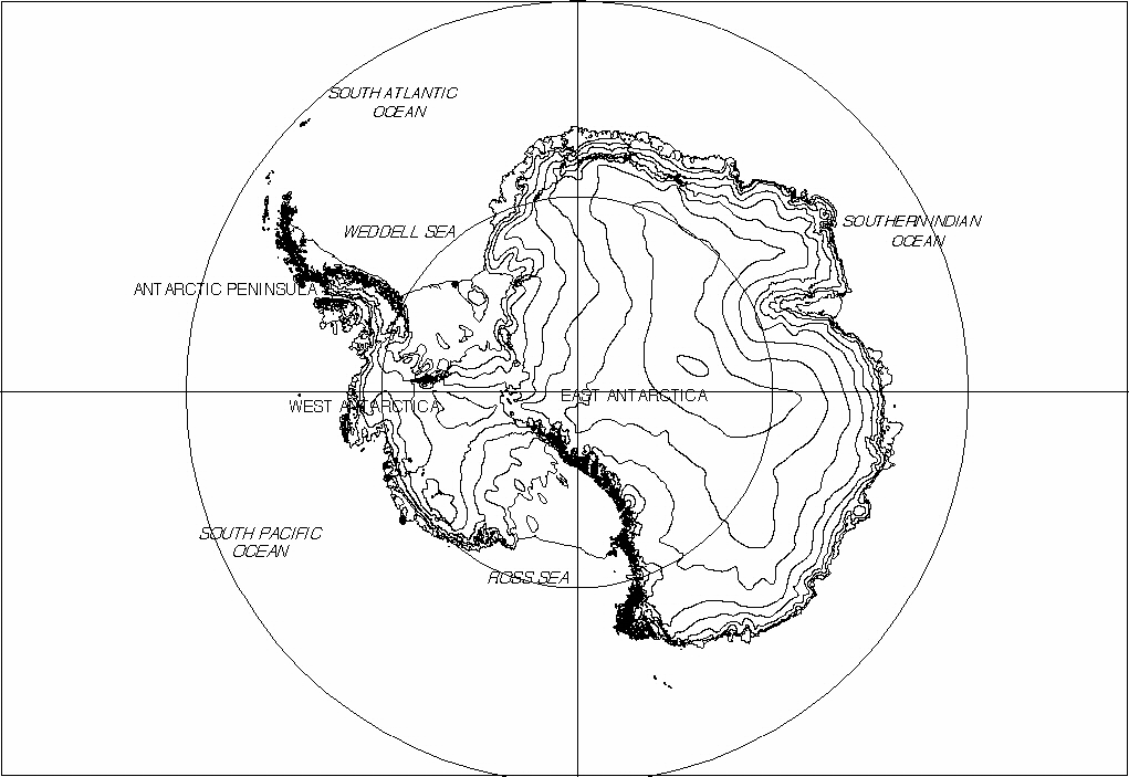
Figure 1 - Locality map of Antarctica.
A concept for the preliminary implementation of ITASE (ITASE Planning Document, 1992), including proposed national components, was formally recommended to XXII SCAR (Scientific Committee for Antarctic Research) at the 1992 meeting in Bariloche, Argentina by the Working Group on Glaciology. At this meeting the SCAR delegates approved ITASE as Recommendation Glaciology XXII-5. Further it was clearly established at this time that ITASE could make notable contributions to the six main SCAR initiatives dealing with the crucial role Antarctica plays in global change. ITASE was subsequently formally accepted under one of SCAR's primary initiatives, GLOCHANT (Global Change in Antarctica) during the XXIII SCAR Meeting in Cambridge, England.
ITASE was formally adopted as a Past Global Changes (PAGES) project in 1993 under PAGES Focus II on Paleoclimate and Environmental Variability in the Polar Regions, within the International Geosphere-Biosphere Programme (IGBP).
Since the 1991 SCAR meeting progress has been made toward implementing ITASE, although the primary energy of the international ice coring community has been directed toward deep drilling at the Summit site in Greenland and various deep drilling activities in Antarctica. Since the successful completion of deep drilling in Greenland the international ice coring community has begun to focus even more attention toward activities in Antarctica. At the same time several other major scientific efforts in, for example, paleoclimate research, glaciology, geophysics, atmospheric chemistry and meteorology have defined scientific objectives that could be served by ITASE.
International interest in ITASE culminated in a workshop held in Cambridge, United Kingdom, on the 2-3 August, 1996. This implementation plan is largely compiled from the presentations, discussions and agreements reached during that meeting. Prior to this meeting a US ITASE workshop was held in Baltimore, Maryland, USA, in May, 1996, where a significant national ITASE programme was developed, and subsequently published as the US ITASE Science and Implementation Plan (US ITASE, 1996). This document reflects the combined efforts of the participants in these two workshops.
Rationale and Scientific Objective
Antarctica plays a critical role in the dynamic linkages that couple the spatially and temporally complex components of the Earth's system (atmosphere, biosphere, anthrosphere, hydrosphere, cryosphere, lithosphere and cosmogenic input). However, our knowledge of the functioning of Antarctica within the global system and the spatial and temporal complexity of Antarctic climate is poor, which is largely due to the limited and the short period of observational and instrumental data on Antarctic climatic variables, collected over the last 30-40 years. Fundamental questions remain in this approach, which include: How typical of Antarctic climatic history are the last 30-40 years? Has Antarctica experienced a typical spatial climate pattern over the last few centuries to thousands of years, as suggested for other regions of the globe (eg., the Little Ice Age and Medieval Warm Period)?
To complicate matters, Antarctica exhibits significant regional contrasts in present day climate. As an example, evidence from instrumental records suggests some decoupling of climate change on decadal scales between different parts of the continent. Large areas of the interior of the ice sheet are influenced by the continental temperature inversion whilst other portions of the interior and the coastal regions are influenced by the incursion of cyclonic systems that circle the continent. As a consequence these coastal regions are mainly connected with lower tropospheric transport whereas high altitude regions in the interior are more likely influenced by vertical transport from the upper troposphere and stratosphere. As a result the coastal regions experience higher climatic variability than those regions in the interior.
High resolution ice core records are now recognised as the most direct means for procuring records that document the soluble, insoluble, and gaseous components of the atmosphere at resolutions as fine as seasonal and, potentially, on time scales as long as a million years. Such records provide us with the resolution needed to interpret past environments and the perspective we need for predictive modeling. While ice core records are potentially available from a wide variety of geographic locations, those developed from polar glaciers generally have the best preserved records. The components transported by the atmosphere and captured in glacial ice document both the responses to environmental change and many of the forcing factors that control and/or modify this change.
The spatial distribution of Antarctic palaeoclimate time series interpreted from ice-coring studies is show in Figure 2. Whilst palaeoclimate time series covering 10,000 to a few 100,000 years have been obtained at several sites across Antarctica, high resolution time series covering the last few hundred years are sparse. The bulk of the time series obtained so far cover the last 10-20 years and the present spatial distribution of time series do not allow for a detailed analysis of variability in the Antarctic and Southern Ocean climate.
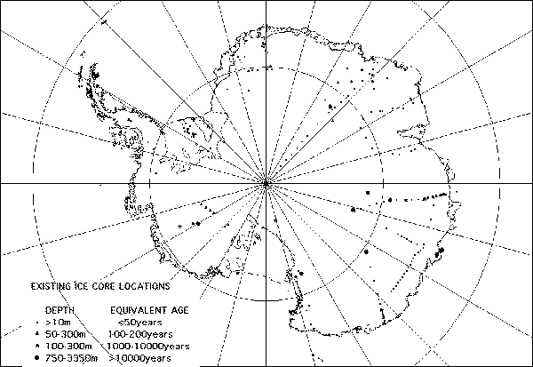
Figure 2 - Map of the spatial distribution of Antarctic firn and ice core sites where either a snow accumulation, oxygen isotope (∂18O) or glaciochemical time series, and/or borehole temperatures have been measured. Very few complete multi-parameter ITASE type records have been collected, apart from a small percentage of the deep ice cores. Note that the bulk of the time series span between 10-20 years. The metadata have been compiled in the ITASE data directory. Note also that it is one of the aims of ITASE to combine and supplement new ice core recovery activities with data rescue for some of these locations. Previous ice core records where they exist, will be reinterpreted, and some archived ice cores will be re-analysed for chemistry and ∂18O isotopes.
However, the deep ice-coring studies have shown that Antarctica has experienced similar millennial to decadal scale climatic variability to that revealed from Greenland ice cores (Bender et al., 1995; Mayewski et al., 1996). This variability is characterized by notable changes in temperature, snow accumulation, wind-blown dust, sea-salt loading and methane composition. Such studies have highlighted the possibility that dramatic shifts in the patterns of atmospheric circulation may explain the rapidity and magnitude of the change in the above parameters.
High frequency climatic changes also occur on interannual timescales, and have been attributed to the El NiÒo Southern Oscillation (ENSO) and other regional to global scale factors, that are associated with atmospheric blocking, sea-ice variations and volcanic event induced shielding.
ITASE has been focused to address the fundamental issues of spatial and temporal climatic and environmental variability, through these key scientific objectives:
To determine the spatial variability of Antarctic climate (eg. accumulation, air temperature, atmospheric circulation) over the last 200 yrs, and where the data are available the last 1000 years.
These variations include: major atmospheric phenomena such as ENSO; snow accumulation variations; and extreme events such as volcanic eruptions and storms.
-
To determine the environmental variability in Antarctica over the last 200 yrs, and where the data are available the last 1000 years. Because of the remoteness of the continent, Antarctica is an ideal location to monitor biogeochemical cycles and global scale changes.
Environmental proxies could include: sea ice variation, ocean productivity, anthropogenic impacts; and other, extra-Antarctic continental influences.
In fulfilling these objectives ITASE will: produce continental scale "environmental maps"; elucidate transfer functions between components of the atmosphere and snow/ice; verify atmospheric models; and interpolate spatial time-series determined from satellite remote sensing. In addition, the identification of spatial gradients in ice core properties is essential to the interpretation of the deep ice core records (Figure 1), interpreted at Vostok, Byrd, Dome C, Taylor Dome, and presently being obtained from the more recent drilling activities at Dome C (France and Italy), Vostok (Russia, France and the U.S.), EPICA (joint European), Filchner-Ronne (England and Germany), Law Dome (Australia), Dome Fuji (Japan) and West Antarctica (U.S.)
ITASE Steering Committee
A steering committee was selected for the ITASE programme, such that all national programmes were represented. The steering committee (see Appendix A for contact details) is as follows:
Prof. Paul Mayewski, University of Maine, USA, Co-Chairman,
Dr. Ian Goodwin, Antarctic CRC, Australia, Programme Coordinator, Co-Chairman,
Prof. David Bromwich, Ohio State University, USA,
Dr. Qin Dahe, Lanzhou Institute of Glaciology and Geocryology, China,
Prof. Per Holmlund, University of Stockholm, Sweden,
Dr. Elisabeth Issakson, Norwegian Polar Institute, Norway
Dr. Massimo Frezzotti, ENEA, Italy
Dr. Michel Fily, Laboratoire de Glaciologie et Geophysique de Environnement, France,
Dr. Volodia Lipenkov, The Arctic and Antarctic Research Institute, Russia,
Prof. Heinz Miller, Alfred Wegner Insitute fur Polar und Meeresforschung, Germany,
Dr. Fumihiko Nishio, Chiba University, Japan,
Dr. David Peel, British Antarctic Survey, UK,
Dr. Jefferson Simoes, LAPAG Insitute Geociencias, Brazil,