

Chilean Scientific Terrestrial Expedition to Lake Ellsworth, January 2006
Andrés Rivera, Scientific Leader email: arivera at cecs.cl CECS: Centro de Estudios Científicos, Valdivia, Chile UCH: Universidad de Chile, Santiago, Chile
Expedition members Lake Ellsworth traverse:
PhD Andrés Rivera, Scientific director, Glaciologist, CECS and UCH
Colonel Guillermo Neira, Communications, Chilean Army
PhD Jens Wendt, Geodesy, CECS
Engineer Rodrigo Zamora, Radar, CECS
Mr. Marcos Rodríguez, Logistics and Mountain Specialist, CECS
Expedition members at Patriot Hills:
PhD Anja Wendt, Geodesy, CECS
Lieutenant Colonel Luis Araya, communications, Chilean Army
Engineer David Ulloa, Radar, CECS
Engineer Marcelo Arevalo, Logistics and Mountain Specialist, CECS
This Southern Hemisphere summer a new Chilean scientific terrestrial expedition will take place in Western Antarctica, which is organized by Centro de Estudios Científicos, Valdivia, Chile (CECS), the private company, Antarctic and Logistic Expeditions (ALE) and the Chilean Army, with collaboration of the University of Kansas, USA, the University of Bristol, UK, the Chilean Air Force, the Chilean Minister of Defense and the National Institute of Polar Research of Japan.
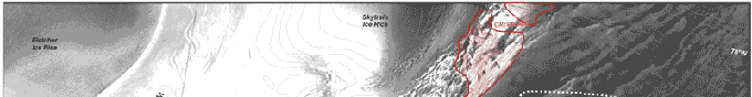
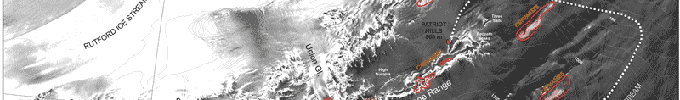
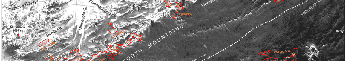
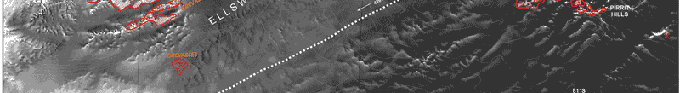
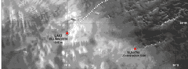
The main aim of the campaign is the glaciological study of Institute Ice Stream and the surroundings of subglacial Lake Ellsworth (90.6°W 78.9°S). This operation will start at Punta Arenas, Southern Chile, from where an Ilyushin airplane of ALE will transport instruments, cargo and personnel to Patriot Hills (80.3°S), where it will land with wheels on the local blue ice area. At Patriot Hills, ALE has a tractor that will tract four sledges, some of them used last year in the first Chilean terrestrial traverse to South Pole. (see Chile 2004) Three fiber glass modules will be used, including a bathroom, a scientific room and an office/kitchen/resting room for scientists.
 |
|
 |
|
 |
|
 |
|
 |
 |
Higher Resolution Map (1.8 M)
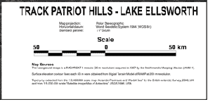
The planned track (Figure 1) has approximately 426 km following one tributary of Institute Ice Stream. This track has been carefully analyzed using ASTER and RADARSAT satellite images, following similar procedures used by USA expeditions. Prior departure from Patriot Hills, an airborne survey will be conducted by ALE Twin Otter airplanes allowing for more close analysis of possible crevasse fields.
During the traverse from Patriot Hills to Lake Ellsworth, a CECS radar system (GSSI model SIR3000 400 MHz) will be permanently operating allowing detection of ice crevasses. Several other instruments will be mounted onboard the convoy, including a radar for measuring ice thickness and the internal structure of the ice (University of Kansas model CARDS 150 MHz). Geodetic quality GPS receivers (Javad model Lexon GD) will also be used during the traverse allowing a high accuracy mapping of the surface topography. Stakes will also be planted each 20 km allowing ice velocities measurements. Snow density measurements will be taken at each stake allowing mass balance estimations. Snow samples will also be collected at each stake for biological studies. In the surroundings of Lake Ellsworth, several radar and GPS profiles will be surveyed, in order to better map the extension of this and other possible subglacial lakes. A permanent GPSstation will be setup at Patriot Hills allowing a differential correction procedure for cinematic measurements collected onboard the convoy. A second GPS station will be establish on a nunatak near Lake Ellsworth (Johns Mountain, 79.6°S 91.3°W) allowing a shorter base line for ice velocities and ice elevation changes measurements. This expedition is part of the International Trans-Antarctic Scientific Expeditions (ITASE) and the Lake Ellsworth Exploration Program.