 Draft Proposal 2004 - page 6
US ITASE
US involvement in ITASE is consistent with priorities established in numerous national and international science plans (e.g., Ice Core Working Group, 1989; Polar Research Board, 1986; WAIS, 1995; IGBP, 1990, National Academy Pathways (eg., Mayewski and Barron, 2000), Future of Ice Cores Meeting 2002). In addition, it is consistent with the objectives established in NSF’s “Supplemental Environmental Impact Statement for the United States Antarctic Program” (SEIPS, 1990), since US ITASE provides an environmental (climate, snow, ice and atmospheric chemistry) framework from which to assess change. Further, the aims of ITASE closely parallel the objectives of NSF’s Global Change Research Program, which emphasizes the need for the collection of paleoclimate records, understanding ocean-atmosphere-land-ice interactions, and scaling of dynamic behavior and biogeochemical cycling.
Over the course of a two-day workshop (Baltimore, May 1996) 37 participants formulated the focus for US ITASE (US ITASE Science and Implementation Plan, 1996) in the context of both ITASE and major US research interests such as the West Antarctic Ice Sheet Initiative (WAIS, 1995). Five major research disciplines were represented: meteorology, remote sensing, ice coring, surface glaciology and geophysics. Atmospheric chemistry has since been added. Summaries describing the state-of-the-art of these disciplines in the context of US ITASE are described in detail in US ITASE Abstracts (1996).
The concept favored both by the scientists and by the NSF delegation attending the meeting was to keep the logistical impact and the science budgetary impact modest by spreading research over a number of years while maintaining a strong focus on goals and interdisciplinary coordination. In this sense, US ITASE provides a level of coordination and collaboration among several projects that can all potentially contribute to each other’s scientific goals. An excellent example is the synergy between GPS activities conducted by G.S. Hamilton and shallow radar profiling conducted by S.A. Arcone on West Antarctic US ITASE traverses. Projects such as these provide information not usually available in single discipline projects. US ITASE acts as “scientific glue” allowing all US ITASE projects to fulfill their scientific goals more efficiently and robustly than if they were supported as individual efforts.
US ITASE research projects complement and support each other to produce a spatial and temporal understanding of climate, environment and ice sheet
behavior. At the Baltimore meeting a mechanism for this process was developed that includes a four-phase approach (traverse planning, traverse sampling,
reoccupation of selected sites, interpretation and modeling). This approach links modern meteorological and remote sensing studies to ground-based
sampling (ice cores, radar, surface sampling, atmospheric sampling); continued monitoring (meteorology and ice dynamics); and interpretation and modeling.
Four traverse routes were selected at the US ITASE Baltimore meeting in order to satisfy US ITASE objectives in West Antarctica and to provide the
necessary spatial sampling of West Antarctica (Figure 1). Route selection and site mapping was conducted by G.S. Hamilton under a separate award in
cooperation with the US ITASE SMO and US ITASE researchers. (These activities are combined in the current proposal.)
We expect to follow a similar model, if this proposal is successful. Researchers selected through OPP peer review to be involved in the proposed traverses, will meet at the scheduled annual US ITASE meeting (usually coincident with US ITASE presentations at AGU) to develop details of traverse routes and science. They will, as in past years, also have discussed this route and logistics in detail prior to submission of the Support Information Package (SIP) to Raytheon and OPP.
A preliminary draft traverse plan, developed by several current US ITASE investigators is presented in this proposal (Figure 1). The proposed route is similar to that followed by the British Commonwealth Trans Antarctic Expedition (1958) from South Pole to Southern Victoria Land. In its current configuration the traverse route contains several side traverses perpendicular to the main route (satellite traverses). The satellite traverses allow the examination of atmosphere and ice gradients along and up flowline from several major outlet glaciers draining the Transantarctic Mountains. We expect that the final traverse route will be modified slightly to accommodate the scientific goals of successfully funded projects.
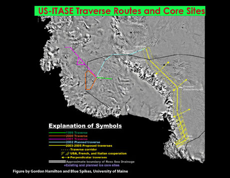
Figure 1. AVHRR mosaic of the Ross Sea sector of Antarctica showing traverse routes for the West Antarctic phase of US ITASE and the proposed route for the Taylor Dome to South Pole phase. Note satellite traverse routes and regions of research by Italian and French ITASE teams that will be integrated with US and Australian ITASE activities to produce a south to north examination of the region inland of the Transantarctic Mountains and Wilkes Land (Wilkes Land not entirely shown on this figure).