
Page 6 of 9
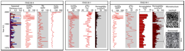
Figure 5 – High-resolution US ITASE ice core records are analyzed for a variety of parameters including: major ion chemistry (Na+, NH4+, K+, Mg2+, Ca2+, Cl-, NO3-, SO42-), stable isotopes, reversibly deposited species (H2O2, HCHO) and physical properties. Annual layers are determined through high resolution sampling (minimum 10 samples per year to significantly greater sampling) and identification of seasonality in a variety of parameters (eg., Na, non seasalt (nss) SO4, seasonal thickness, and where not post-depositionally altered stable isotopes and H2O2). Annual layer dating is calibrated using known volcanic events identified by SO4 spikes traced from site to site. Volcanic eruptions in mid 1990’s are picked up in all three locations as highlighted in the figure. Changes in accumulation rate are derived from measurements of density (not shown) and annual layer thickness. Changes in other climate parameters such as temperature and sea level pressure are developed from calibration between instrumental and ice core records of stable isotopes and major ions, respectively (eg., Figure 6). Measurements of permeability and microstructure are used to assess post-depositional changes in the firn and snow and their effects on reversibly deposited chemical species. Significant site to site variations exist in permeability and microstructure. The data shown come from the upper sections of ice cores collected during the 99-00 and 00-01 field season. See Figure 3 for locations of the datasets (99-1, 00-1, 00-4) presented in this figure.
|
Ice core parameters (eg., methane sulfonate, stable isotopes) and ice sheet surface climate are very closely linked to large-scale atmospheric circulation patterns such as ENSO (Meyerson et al., in press) and the AAO (Schneider and Steig, 2002). Reconstruction of these patterns prior to the instrumental record, which would not be possible with a single ice core, will be achievable with the multi-site, multi-proxy records gathered by US ITASE, As Figure 6a illustrates, data from the ice sheet surface alone (in this case, temperature data derived from satellites) provides sufficient information to reconstruct the ENSO teleconnection pattern over West Antarctica. We have not yet compiled data from all ice cores, but the results are extremely promising, as illustrated by the confirmation with new US ITASE data of the original finding of Kreutz et al. (2000) at Siple Dome, that low pressure anomalies – which may also be related to ENSO forcing – can be detected with ice core sodium concentration data, because advection of sea salt to the ice sheet is enhanced when the Amundsen Sea Low is strong. Using relationships such as these, US ITASE surface climate reconstructions for West Antarctica will ultimately allow for large-scale reconstructions of Southern Hemisphere climate variability for sub-annual to multi-decadal and low frequency modes of the climate system, extending far beyond the available instrumental record. Mass balance The calculation of local rates of change relies on accurate long term accumulation rate averages derived from ice core stratigraphy. In addition, the interpretation of satellite altimeter derived surface elevation changes in terms of ice equivalent thickness changes requires that temporal variability in accumulation rate be known. |
Snow accumulation is a standard parameter derived from ice core records. For ice core sites not located on flow divides, accumulation rate patterns are convolved with ice flow effects due to ice motion through an undulating topography Local accumulation rates can exhibit variability because of this effect. At each of the US ITASE core sites (eg., Figure 3), we have measured local topography, ice flow, and accumulation rate for the distance up-flow corresponding to the length of the record. Surface glaciology results from US ITASE sites where data are complete indicate that the interior portion of the ice sheet is close to steady state and is not currently contributing to changes in global sea level. Lower elevations of the Ross Sea drainage, show net thinning of about 10 cm/yr. Repeat GPS occupations of sites in the Amundsen Sea drainage are used by US ITASE to confirm the presence of rapid thinning in this region of WAIS as implied from repeat satellite radar altimetry (Shepherd and others, 1998). Surface glaciology results from US ITASE sites where data are complete indicate that the interior portion of the ice sheet is close to steady state and is not currently contributing to changes in global sea level. Lower elevations of the Ross Sea drainage, show net thinning of about 10 cm/yr. Repeat GPS occupations of sites in the Amundsen Sea drainage are used by US ITASE to confirm the presence of rapid thinning in this region of WAIS as implied from repeat satellite radar altimetry (Shepherd and others, 1998). |
Previous page, Next page, or Download entire paper