
Dr. Joseph T. Kelley
Dr. Daniel F. Belknap
University of Maine
Department of Earth Sciences Climate Change Institute
And School of Marine Sciences
Beaches are visibly dynamic environments. Waves, wind and currents act to move sand and constantly change the appearance of the seashore. It is not a large leap to believe that areas seaward of beaches are also dynamic, with currents and shifting sand bars regularly altering the seafloor. Mudflats, on the other hand, are calm environments with few waves and no strong currents. Who would suppose that seaward of the quiet mudflats exists a seafloor convulsed by violent explosions venting natural gas and ripping up the ocean bottom? Until the advent of modern geophysical mapping systems, no one thought that much happened on the muddy bottom of Maine's estuaries and nearshore region. 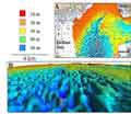
fig.1:click to view
larger and read captionNew ways to image Maine's sea bottom and to see into it now exist. Using such remote sensing geophysical equipment, Drs. Joseph Kelley and Daniel Belknap and their graduate students at the University of Maine Climate Change Institute and Earth Science Department recently published a paper in the journal, Marine Geology, reviewing new discoveries on the muddy ocean bottom of Maine. Based on Sea Grant-funded research, they conclude that the old view of quiet muddy environments needs serious revision. 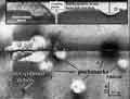
fig.2:click to view
larger and read caption In every muddy embayment in Maine, but not in sandy ones, natural gas bubbles occupy up to several percent of the space between bits of mud. In many locations, Casco Bay, Blue Hill Bay, Somes Sound, and Belfast Bay, to name some, methane gas has apparently escaped from the seafloor with sufficient violence to create "pockmarks", or craters on the bottom. In Belfast Bay, these craters range up to several football fields in diameter and more than 100 feet deep. Imagine a crater the size of the Sea Dogs stadium, including the bleachers. Such a pockmark would not be the largest, and there are thousands of these features in Belfast Bay alone. 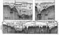
fig.3:click to view
larger and read captionBelow the surface, limited light filters through the muddy water, making first-hand observations difficult. In a world where light performs poorly at illuminating large areas, sound comes to the rescue of research scientists in the ocean. Known for its application to measure water depth in a fathometer, sound waves precisely transmitted by a computer can bounce off the bottom very rapidly and accurately map bottom depths across large areas. Devices that perform multibeam bathymetry map water depths hundreds of meters to the sides of boats even while they travel at relatively high speeds. The resulting color-coded, shaded relief maps (Figure 1)allow scientists to rapidly measure shallow and deep areas. Sound can be used to image objects on the bottom with views that look like black and white aerial photographs (Figure 2). This is the sort of device that was used to find the Titanic. Sound waves also penetrate the seafloor to reflect back off layers of sand and mud beneath the bottom (Figure 3).