
Page 3 of 9
|
US ITASE also contributes to our knowledge of current and future projected changes in sea level by improving understanding of ice sheet mass balance. The US ITASE logistics platform provides a base for the collection of field mass balance measurements for large portions of West Antarctica, an area which currently accounts for the greatest uncertainty in global estimatesof icesheet contributions to sea level change. US ITASE is examining two of the major West Antarctic ice drainages (Ross Sea catchment and Amundsen Sea catchment) where existing studies indicate contrasting styles of behavior (Shepherd and others, 1998; Joughin and Tulaczyk, 2002). US ITASE Program Description US ITASE has developed a suite of field experiments and observations utilizing an over snow traverse platform (Figure 2 above) that has now covered >5000 km (Figure 3, next page) with studies at a variety of spatial scales extending from the subglacial bedrock (>3000 m), through the surface of the ice sheet, to >20 km into the atmosphere (Figure 4, next page). For each of several stations, spaced approximately 100-200+ km apart (Figure 3), we have obtained high-resolution isotopic, geochemical, and physical measurements from numerous ice core and snowpit profiles ranging in depth from 15-115m (typical sites 60-70m). |
At each site, global positioning system (GPS) measurements of differential vertical velocity are gathered to study mass balance variations. Calculated rates of ice sheet thickness change from the GPS work are used for interpreting the ice core records of snow accumulation, and as ground-truthing for surface elevation histories derived from NASA’s ICESat laser altimetry mission. In addition to the ice core and GPS measurements, we have obtained high resolution radar records of the entire firn structure to reveal the spatial variation in annual layering and to interpolate accumulation rates between coring sites. This radar work is unprecedented in its combination of high resolution (<35 cm) and depth (>100 m). At each site, detailed snow stratigraphy measurements are also made, including annual layering, grain growth, permeability and microstructure profiles which are important for understanding the influence of vertical and horizontal mass transport on the geochemical species used in the climate reconstruction. This is complimented by measurements, both in the snow and in situ in the atmosphere, of reactive chemical species (eg., formaldehyde, hydrogen peroxide), that may be only partly preserved in the ice, yet are critical to our understanding of global atmospheric chemistry. Finally deep radar soundings are used to correlate surface and bottom topography, to assess basal melting, and to aid in the selection of specific sites for future deep coring projects. |
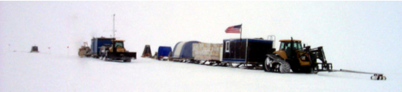
Figure 2 – US ITASE traverse tractors and sleds. Crevasse detection equipment mounted on lead tractor. Sleds contain berthing, kitchen, fuel drums, scientific equipment, and ice cores.
Previous page, Next page, or Download entire paper