
- 1999
- 2000
- 2001
- 2002
- 2003
- 2006
- 2007
Week 7 - December 9, to December 15, 2002
Hermiony, the bean bag frog, takes a walk around McMurdo. Hermiony's photo album.
Date: 12/15/02
Latitude: 83 degrees, 30 minutes, 02.81 seconds South
Longitude: 104 degrees, 59 minutes, 12.73 seconds West
Temperature: −30°C( −22°F)
Wind speed: 35 knots
Wind Chill: −51°C( −60°F)
Wind direction: East Northeast
Meters of ice collected: 203
Notes on daily life:
By Dan Dixon
Today the weather went from bad to worse. The incessant winds were blowing so much surface snow that it was difficult to see more than 20 feet. It
was nearly a complete whiteout. Paul, our field leader, called off work for the day so we all spent our free time doing odd jobs, reading, chatting,
sleeping, and many other things that are not possible while working.
I spent the morning making short movies of the storm with my digital camera. I cut out a hole in a plastic bag and stuck the camera lens out through it; this reduces the amount of snow getting in to the camera body. Even with the plastic bag cover, the camera became covered in snow after about 15 minutes and I had to put it back inside to dry off. The snow particles are so fine, and the winds are so strong, that snow eventually finds its way into every nook and cranny imaginable.
After my 15 minutes of movie making, I went to the kitchen for some breakfast. Even this turned out to be a challenge as several large snowdrifts had established themselves between the blue room and the kitchen overnight. After a lovely breakfast I headed out to the clean air sector to get a fresh surface snow sample. The clean air sector is situated about 250m upwind of the camp, this ensures that none of the exhaust from the tractors or generators can possibly contaminate the air or snow in that area. The atmospheric air sampling tent, the drill site, and the surface snow collection area are all situated in the clean air sector. The path to the clean air sector is marked every 20–25 feet with flags; today the conditions were so bad that you could only see one flag–distance ahead. The walk out was like an adventure into nothingness, just pure white with a single flag to guide you.
After collecting the surface snow sample and helping Betsy shovel snow around the edges of the atmospheric sampling tent (to help keep the wind out), I returned to the shelter of the blue room. I attempted to take off my outer layers of clothing only to find that everything was iced up, my gloves, neck gaiter, goggles, and hat were frozen solid. I even had to thaw out the zipper of my jacket before I could get it undone; I had only been outside for about half an hour!
After thawing out and warming up for a while in the blue room, I decided to head back out and make some more movies. It took another 15 minutes for my digital camera to get snow covered again, but I managed to get some good storm footage including the primal–sounding howl of the blue room wind generator. When I returned to the blue room to warm up again I found that all my clothes had frozen rock hard like a suit of armor! During my early morning foray into the snow my clothes had gotten quite wet and had not had a chance to dry out thoroughly, so as I went back out into the freezing winds a second time my clothes had frozen around me like a hard shell. After this little experience I decided to take my time and dry out completely, I spent the rest of the day in the warmth of the blue room and kitchen. Before bedtime we watched another DVD movie in the blue room, this time it was Eddie Murphy in "Delirious".
Date: 12/14/02
Latitude: 83 degrees, 30 minutes, 02.81 seconds South
Longitude: 104 degrees, 59 minutes, 12.73 seconds West
Temperature: −27°C( −17°F)
Wind speed: 30 knots
Wind Chill: −46°C( −50°F)
Wind direction: East Northeast
Meters of ice collected: 203
Notes on daily life:
By Brian Welch
The storm that started during the last 30 kilometers of yesterday’s traverse is still with us today with slightly stronger winds and colder temperatures.
It makes for cold conditions for the ice coring crew, atmospheric chemistry and glaciology research as well as for the mechanics doing routine maintenance
on the tractors. For those of us who ran the radar systems during yesterday’s traverse it’s an opportunity to back up our collected data
onto CD–ROMs and to do some preliminary data processing.
There are three radar systems on the traverse that operate at all times while we’re traveling. Two are high–frequency systems, one to look for crevasses and another to collect near–surface data to correlate with the ice cores.
The third radar system is in the last sleds of the traverse. This is a deep–penetrating radar system run by Brian Welch. This system uses a lower radio frequency (3 MHz) to penetrate as much as 3 km of ice to the bedrock below. The system also records internal ice layers caused by volcanic deposits or changes in the ice properties such as the transition between the last glacial period and the current interglacial period. As with the shallow radar these internal layers represent isochrones, lines of constant age, in the ice sheet. The deep radar can’t recover data in the upper 100 m of ice so it can’t be used with the shallow ITASE cores, but it will be useful for future deep drilling efforts in West Antarctica and provides some of the first measurements of ice thickness in this region.
Being the operator of the deep radar during one of the traverse legs is an experience quite different from the rest of the ITASE crew. The system consists of two sleds: the first is 75 m behind the last sled of the second train and contains the radar receiver, essentially and amplifier, oscilloscope, and computer; the second is another 135 m behind the receiver and contains the radar transmitter and its battery. The entire system is a little longer than two football fields.
The receiver shelter is an insulated plywood box that is 6.5 ft long, 5 ft wide, and 5 ft tall. It has a small shelf for the computer, a chair on one side, and space for my sleeping bag along one wall. This is where I live during the traverse. There are three small windows that provide views of the ice (when they’re not covered with frost) as well as small vents for air circulation. The door out the back of the shelter opens onto a small platform that contains the generator that powers the system.
Because the sled is so small and on such a long rope the ride can get somewhat interesting. If the snow is soft the sled can bottom out and actually stop until the rope is stretched to its full length before snapping forward. It’s something like a horizontal bungee–jump experience except that it happens every 20 seconds for 20 to 30 hours! If the terrain is hard and rough the sled bounces around and I spend much of my time catching items that are falling off the shelf (pens, notebooks, the car batteries that are being charged to keep the transmitter running).
The long traverses are the most difficult as I need to stay awake for the entire trip (sometimes as long as 50 hours) in order to monitor the radar system. The rough terrain can break an antenna, the generator needs gasoline at regular intervals, the transmitter batteries need to be charged and swapped every few hours, or there may be a change in the appearance of the bedrock or ice layers that should be recorded in my notes. A few other team members have helped out when possible, but many have experienced motion sickness I can’t imagine why! For some reason I can’t explain I don’t seem to feel the same ill effects even though I can’t stand things like roller coasters. Despite the rough ride I find that after 20–30 hours of a traverse leg I will occasionally doze off in my seat without realizing it. When this happens I’m usually jolted awake by falling out of my seat as we go over a bump or when my forehead hits the computer shelf.
In the end, when we’re back home looking at the data all of the rough conditions and cold weather don’t seem quite so bad. While we’re here in the field it’s a tiring job and it’s hard to get excited about each long traverse leg. For the moment I’m resting up and planning to put some foam padding on the edge of the computer shelf I’m getting a bit of a lump on my forehead!
Date: 12/13/02
Latitude: 83 degrees, 30 minutes, 02.81 seconds South
Longitude: 104 degrees, 59 minutes, 12.73 seconds West
Temperature: −25°C( −13°F)
Wind speed: 22 knots
Wind Chill: −41°C( −42°F)
Wind direction: East Northeast
Meters of ice collected: 189
Notes on daily life:
It has been a long and bumpy ride, but it has taken significantly less time than expected. It took us a total of 28 hours at approximately 9 km/h (including way point and refueling stops) to reach Site 2. We traveled a total distance of 177 km and went up 240 m in elevation. We are now camped at approximately 2000 m above sea level. At our present location the average temperature is considerably cooler than at Site 1, this is mostly due to our increased elevation. As elevation increases, the average temperature decreases (the wind chill does not help matters much either). Hopefully, the wind will calm down by morning and make our work more enjoyable. In subzero temperatures like these it is relatively easy to protect yourself from the cold, but it is much more difficult to protect your entire body from a 22 knot wind.
As we set off from Site 1 yesterday morning, the skies were clearing, the sun was shining, and the Whitmore Mountains were just coming into view. It was yet another quintessential Antarctic day, absolutely perfect. The mountains were a particularly nice change to the usual scenery in which white cloud meets white horizon with no particular boundary, a bit like being on the inside of a white ball. Initially, the topography here seemed to be completely flat, but as we progressed on our journey we noticed the mountains on the horizon disappearing and reappearing again and again. Upon closer inspection of the GPS elevation data it was apparent that we were traveling over subtle hills and bowls, as well as gradually gaining height. For most of the day the sun was shining so intensely that the sparkling snow surface seemed alive, as if millions of tiny little flashbulbs were going off at every moment. To relieve some of the boredom of the journey, several of the ITASE crew decided to do a bit of blue–room roof riding. This didn’t last long however, as the biting cold and wind drove them all back into the shelters for warmth. Most of the crew hasn’t the time to get bored because the driving, radar, and GPS shifts.
Tonight, we shall all sleep like logs and with a little bit of luck we shall awaken to another glorious morning.
Date: 12/12/02
Latitude: 82 degrees, 00 minutes, 03.59 seconds South
Longitude: 110 degrees, 00 minutes, 29.59 seconds West
Temperature: −20°C( −4°F)
Wind speed: 5 knots
Wind Chill: −27°C( −16°F)
Wind direction: Northerly
Meters of ice collected: 189
Notes on daily life:
Today we finished up the remaining science experiments at Site 1, re–packed all the sleds, prepared the trains, and set off for Site 2. The sky is
clearing and the remaining thin clouds look beautiful as the sun shines through and creates a multitude of rainbows. As the clouds thin on the horizon,
it is just possible to make out the faint outline of the Whitmore Mountains in the distance. By the time we reach Site 2 we will be within 40 km of
the mountains – this should make for a refreshing change of scenery. It will be another long haul to Site 2 (177 km), but significantly less than the
Byrd to Site1 trip. We are expecting to be ‘on the road’ for at least 24 hours.
As usual, we will take six–hour shifts for the driving, and also run GPS, shallow radar, and deep radar for the whole 177 km. It’s going to be
another bumpy ride!
Date: 12/11/02
Latitude: 82 degrees, 00 minutes, 03.59 seconds South
Longitude: 110 degrees, 00 minutes, 29.59 seconds West
Temperature: −16°C( 3°F)
Wind speed: 6 knots
Wind Chill: −23°C( −9°F)
Wind direction: Northerly
Meters of ice collected: 142
Notes on daily life:
As Betsy put it, “We were busy as a beehive in the middle of nowhere today.” It was an overcast day, but the winds died down and made working outside a pleasure. Betsy did three successful ozone measuring balloon launches (the beanie babies went along for one of the launches). Markus drilled 2” ice cores for the continuous melter and worked on a firn air vs. snow air ozone concentration experiment. Gordon and Blue did a survey at their mass balance site and started drilling the Beta ice cores with the 2” drill. Paul, Mark, Dan and Susan drilled ice cores with the 2” and 3” drill. Brian worked on his radar antennas, and Jim was the man around town helping Brian and Betsy out and double–checking the radar data. Lynn and Carl welded brackets for a tailgate for the Berco sled, loaded empty fuel barrels on the sleds and organized cargo. Andrea was again successful at fattening us up and keeping us happy. We had a yummy BBQ dinner with fresh potato salad.
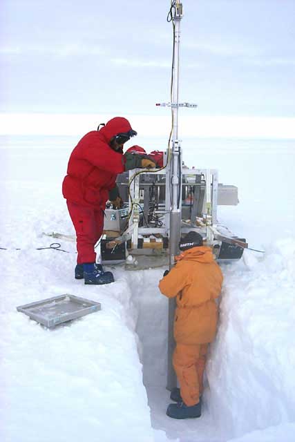
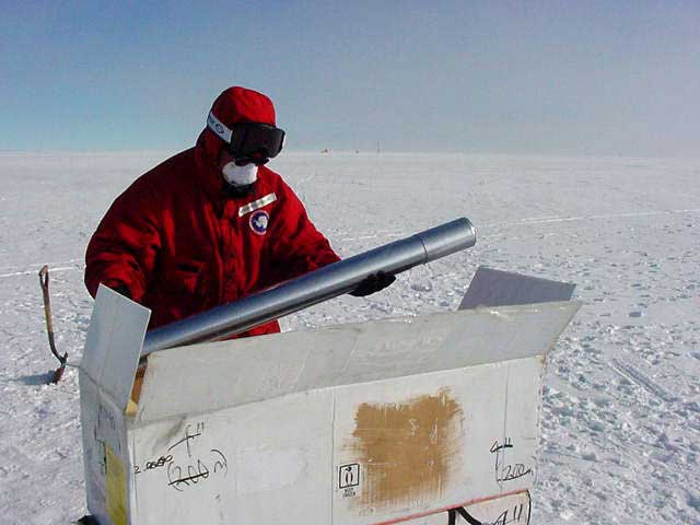
The name of the game in camp today was ice core drilling. US ITASE uses two drills, the 2” diameter drill, and the 3” diameter Eclipse drill that is our primary drill. The Eclipse drill was designed by Icefield Instruments of Whitehorse, Yukon Territory and has been used in Antarctica, on Mt. Everest, in the Tien Shan range in Asia, and on Mt. Logan in the Yukon. The Eclipse drill that we use was specially built and purchased for US ITASE. The advantage of the Eclipse drill is that it is lightweight (800 lbs), can be broken down into 50–60 lbs. bundles, can be assembled in the field, is mounted on a sled, and is a dry drill. Dry drilling has no impact on the environment. In comparison, wet drills go to deeper depths but require fluid that is the same density of ice to keep the drill hole from closing up. The Eclipse drill is an electromechanical drill made of aluminum and stainless steel that can be powered by solar panels or gasoline. The winch on the drill requires 3000 watts of power when raising the core, so we use a gasoline powered generator to run the drill.
The drill has an inner and an outer core barrel. The inner barrel has cutters on the end of it, and as the drill is lowered into the ice the inner barrel spins and cuts the ice. The outer barrel has anti–torque strips at the top of the drill to prevent it from spinning while in the hole. We drill ~1m long pieces of ice. When the drill is lifted the core dogs, which are small cutters with springs attached, grab into the ice, break it, and prevent the ~1 meter long ice core from falling out of the barrel as it is lifted back up out of the hole. Ice chips from drilling the ice core are pulled up with the ice core in the top of the core barrel. Operation of the Eclipse drill requires a professional driller. Mark knows the drill inside out and does an amazing job keeping the drill running smoothly.
After a piece of ice is drilled, the whole drill is lifted out of the hole with the winch, and the core barrel tilts horizontally so the ice core can be extracted. Susan measures the length, diameter and any breaks on the ice core and Dan weighs and packages it for shipment back to the United States. One meter of ice weighs about 4 kg. This adds up to be a lot of weight to haul around in the field. The 2” drill, designed by Mark, is similar to the Eclipse drill except that it is smaller, lighter – only 200 lb. – and is powered by solar panels and a hand winch. We have to dig a 1m pit to lower the Eclipse drill into the ice, whereas the 2” drill can begin drilling at the ice surface, which means we don’t have to dig snow pits. The Eclipse drill is better designed for drilling at deeper depths (it has a 200 m cable) and provides a larger core so that more analyses can be done. The 2” drill’s advantages are that it is lightweight, highly maneuverable, and can be operated without a professional driller.
It’s great to finally be on the road and doing our research. We’ll wrap up our research at site 1 tomorrow, pack up, and the road trip will continue on to scenic site 2.


Date: 12/10/02
Latitude: 82 degrees, 00 minutes, 03.59 seconds South
Longitude: 110 degrees, 00 minutes, 29.59 seconds West
Temperature: −18°C( 0°F)
Wind speed: 16 knots
Wind Chill: −30°C( −22°F)
Wind direction: Northerly
Meters of ice collected: 91
Notes on daily life:
Waking up in a bunk that doesn’t shake, rattle, and roll is a refreshing change. We all slept like logs after our marathon from Byrd Camp. First thing this morning Jim processed the last 50 km of shallow radar data on his laptop computer so that we could select an appropriate location for our science experiments. As luck would have it, the very spot where we stopped turned out to be fine and our fuel drums from the LC–130 air drop are right here too. After a late breakfast we all got to work on our experiments. Unfortunately, the nasty weather that we drove into last night got worse. Bad weather makes work more difficult and less enjoyable, for most of the day it was impossible to see the sun at all.
Despite the weather, we worked hard and managed to complete all that we had set out to do for the day. Markus and Betsy managed to fully set up the atmospheric sampling tent in record time. Blue completed his high–resolution GPS survey around the camp and then he and Gordon installed the mass balance site. Jim finished processing all the rest of the shallow radar data from the first leg of the trip. Brian did some fine tuning to the deep radar antennas and also helped Carl and Lynn dig out the fuel drum bundles, The drums were heavily snowed–in because they were dropped several weeks ago. Dan, Susan, Mark, and Paul set up the drill site and collected more than 20 m of three–inch core and Andrea did another fine job of keeping everyone well–fed.
At the end of this productive and cold day, it was a lovely treat to relax in our bunks and watch yet another DVD movie. Let’s hope the weather improves for tomorrow.
Date: 12/09/02
Latitude: 82 degrees, 00 minutes, 03.59 seconds South
Longitude: 110 degrees, 00 minutes, 29.59 seconds West
Temperature: −12°C( 10°F)
Wind speed: 10 knots
Wind Chill: −20°C( −4°F)
Wind direction: Northerly
Meters of ice collected: 71
Notes on daily life:
After driving for 52 solid hours we arrived at site 1. The weather was lovely for most of the journey, but it turned nasty for the last 30 km. The soft snow conditions are extensive in this entire area of West Antarctica making travel more difficult and time consuming than usual. It has been a long haul for all of us, between the driving, deep radar, shallow radar, GPS, snow sampling, and cooking, we are all very tired. We will not know whether this site is suitable for our scientific studies until we analyze the shallow radar profiles from the last 50 km of the trip. The shallow radar profiles highlight the internal layers in the top 50–100m of the ice sheet. By studying these we can ensure that we pick the best possible locations for our ice core and mass balance sites. Right now we are all glad to be stationary, I think that after a few hours of sleep we will be ready to make a decision.
Date: 12/09/02 extra
Latitude: 77 degrees, 51 minutes South
Longitude: 166 degrees 40 minutes East
Temperature: −2°C( 28°F)
Wind speed: 5 knots
Wind Chill: −5°C( 22°F)
Wind direction: East
Meters of ice collected: 71
Notes on daily life:
By Leigh Stearns
Here is what I learned today. In Antarctica, if you arrange your hand in the 'thumbs up' position and aim it towards the sun, your thumb covers up
the entire sun and the scattering around it. Essentially, the air is so dry and pure that there is minimal scattering. Supposedly, if you do the
same thing in other areas of the world there is either too much smog, pollution or water vapor for it to work. If anyone wants to prove me wrong,
please do. I haven't tried this experiment at home.
Here are some other random tidbits about running a research station in Antarctica:
- Shower cost per minute:
- McMurdo: $0.06
- South Pole: $1
- Cost per gallon of auto fuel:
- McMurdo: $1.25 (less than it is in Maine!!)
- South Pole: $8.00
- Cost of operating a 60–watt light bulb for 1 year:
- McMurdo: $8.00
- South Pole: $590.00
- Gallons of fuel burned each year:
- Ground: 3.1 million
- Aviation: 3.2 million
- Gasoline: 130,000
I am scheduled to have Twin Otter (small, propeller plane) support for December 15–21 for my resurvey work. In the meantime I am preparing for my trip, working on papers in our lab, and going on short hikes around McMurdo.